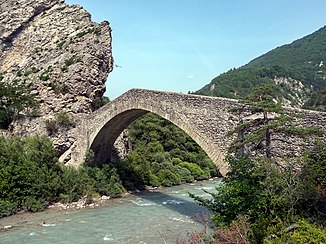
Vanson
|
Vanson Vançon |
||
|
Pont de la Reine Jeanne bridge |
||
| Data | ||
| Water code | FR : X1120500 | |
| location | France , Provence-Alpes-Cote d'Azur region | |
| River system | Rhône | |
| Drain over | Durance → Rhône → Mediterranean | |
| source | in the municipality of Authon 44 ° 15 ′ 38 ″ N , 6 ° 12 ′ 31 ″ E |
|
| Source height | approx. 1860 m | |
| muzzle | in the municipality of Volonne in the Durance coordinates: 44 ° 7 ′ 48 ″ N , 5 ° 59 ′ 10 ″ E, 44 ° 7 ′ 48 ″ N , 5 ° 59 ′ 10 ″ E |
|
| Mouth height | approx. 440 m | |
| Height difference | approx. 1420 m | |
| Bottom slope | approx. 47 ‰ | |
| length | 30 km | |
| Catchment area | 112 km² | |
The Vanson (also written Vançon ) is a river in France that runs in the Alpes-de-Haute-Provence department in the Provence-Alpes-Côte d'Azur region . It rises on the south-eastern flank of the mountain summit Les Monges (2115 m) in the municipality of Authon , generally drains in a south-westerly direction and after 30 kilometers flows into the Durance as a left tributary in the municipality of Volonne .
Places on the river
Attractions
- Pont de la Reine Jeanne , 17th century bridge over the river near the hamlet of Saint-Symphorien in the municipality of Entrepierre - Monument historique
Remarks
- ↑ Source geoportail.gouv.fr
- ↑ estuary geoportail.gouv.fr
- ↑ a b c The information on the length of the river is based on the information on the Vanson from SANDRE (French), accessed on September 29, 2012, rounded to the nearest kilometer.
- ↑ Pont de la Reine Jeanne in the Base Mérimée of the French Ministry of Culture (French)
Web links
Commons : Vanson - collection of images, videos and audio files
