
Nice – Digne-les-Bains railway line
| Nice – Digne-les-Bains | |||||||||||||||||||||||||||||||||||||||||||||||||||||||||||||||||||||||||||||||||||||||||||||||||||||||||||||||||||||||||||||||||||||||||||||||||||||||||||||||||||||||||||||||||||||||||||||||||||||||||||||||||||||||||||||||||||||||||||||||||||||||||||||||||||||||||||||||||||||||||||||||||||||||||||||||||||||||||||||||||||||||||||||||||||||||||||||||||||||||||||||||||||||||||||||||||||||||||||||||||||||||||||||||||||||||||||||||||||||||||||||||||||||||||||||||||||||||||||||||||||||||||||||||||||||||||||||||||||||||||||||||||||||||||||||||||||||||||||||||||||||||||||||||||||||||||||||||||||||||||||||
|---|---|---|---|---|---|---|---|---|---|---|---|---|---|---|---|---|---|---|---|---|---|---|---|---|---|---|---|---|---|---|---|---|---|---|---|---|---|---|---|---|---|---|---|---|---|---|---|---|---|---|---|---|---|---|---|---|---|---|---|---|---|---|---|---|---|---|---|---|---|---|---|---|---|---|---|---|---|---|---|---|---|---|---|---|---|---|---|---|---|---|---|---|---|---|---|---|---|---|---|---|---|---|---|---|---|---|---|---|---|---|---|---|---|---|---|---|---|---|---|---|---|---|---|---|---|---|---|---|---|---|---|---|---|---|---|---|---|---|---|---|---|---|---|---|---|---|---|---|---|---|---|---|---|---|---|---|---|---|---|---|---|---|---|---|---|---|---|---|---|---|---|---|---|---|---|---|---|---|---|---|---|---|---|---|---|---|---|---|---|---|---|---|---|---|---|---|---|---|---|---|---|---|---|---|---|---|---|---|---|---|---|---|---|---|---|---|---|---|---|---|---|---|---|---|---|---|---|---|---|---|---|---|---|---|---|---|---|---|---|---|---|---|---|---|---|---|---|---|---|---|---|---|---|---|---|---|---|---|---|---|---|---|---|---|---|---|---|---|---|---|---|---|---|---|---|---|---|---|---|---|---|---|---|---|---|---|---|---|---|---|---|---|---|---|---|---|---|---|---|---|---|---|---|---|---|---|---|---|---|---|---|---|---|---|---|---|---|---|---|---|---|---|---|---|---|---|---|---|---|---|---|---|---|---|---|---|---|---|---|---|---|---|---|---|---|---|---|---|---|---|---|---|---|---|---|---|---|---|---|---|---|---|---|---|---|---|---|---|---|---|---|---|---|---|---|---|---|---|---|---|---|---|---|---|---|---|---|---|---|---|---|---|---|---|---|---|---|---|---|---|---|---|---|---|---|---|---|---|---|---|---|---|---|---|---|---|---|---|---|---|---|---|---|---|---|---|---|---|---|---|---|---|---|---|---|---|---|---|---|---|---|---|---|---|---|---|---|---|---|---|---|---|---|---|---|---|---|---|---|---|---|---|---|---|---|---|---|---|---|---|---|---|---|---|---|---|---|---|---|---|---|---|---|---|---|---|---|---|---|---|---|---|---|---|---|---|---|---|---|---|---|---|---|---|---|---|---|---|---|---|---|---|---|---|---|---|---|---|---|---|---|---|---|---|---|---|---|---|---|---|---|---|---|---|---|---|---|---|---|---|---|---|---|---|---|---|---|---|---|---|---|---|---|---|---|---|---|---|---|---|---|---|---|---|---|---|---|---|---|---|---|---|---|---|---|---|---|---|---|---|---|---|---|---|---|---|---|---|---|---|---|---|---|---|---|---|---|---|---|---|---|---|---|---|---|
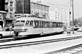
 Diesel multiple unit (AMP 804 + 803) in Nice Gare CP, 2015
| |||||||||||||||||||||||||||||||||||||||||||||||||||||||||||||||||||||||||||||||||||||||||||||||||||||||||||||||||||||||||||||||||||||||||||||||||||||||||||||||||||||||||||||||||||||||||||||||||||||||||||||||||||||||||||||||||||||||||||||||||||||||||||||||||||||||||||||||||||||||||||||||||||||||||||||||||||||||||||||||||||||||||||||||||||||||||||||||||||||||||||||||||||||||||||||||||||||||||||||||||||||||||||||||||||||||||||||||||||||||||||||||||||||||||||||||||||||||||||||||||||||||||||||||||||||||||||||||||||||||||||||||||||||||||||||||||||||||||||||||||||||||||||||||||||||||||||||||||||||||||||||
| Route length: | 150 km | ||||||||||||||||||||||||||||||||||||||||||||||||||||||||||||||||||||||||||||||||||||||||||||||||||||||||||||||||||||||||||||||||||||||||||||||||||||||||||||||||||||||||||||||||||||||||||||||||||||||||||||||||||||||||||||||||||||||||||||||||||||||||||||||||||||||||||||||||||||||||||||||||||||||||||||||||||||||||||||||||||||||||||||||||||||||||||||||||||||||||||||||||||||||||||||||||||||||||||||||||||||||||||||||||||||||||||||||||||||||||||||||||||||||||||||||||||||||||||||||||||||||||||||||||||||||||||||||||||||||||||||||||||||||||||||||||||||||||||||||||||||||||||||||||||||||||||||||||||||||||||||
| Gauge : | 1000 mm ( meter gauge ) | ||||||||||||||||||||||||||||||||||||||||||||||||||||||||||||||||||||||||||||||||||||||||||||||||||||||||||||||||||||||||||||||||||||||||||||||||||||||||||||||||||||||||||||||||||||||||||||||||||||||||||||||||||||||||||||||||||||||||||||||||||||||||||||||||||||||||||||||||||||||||||||||||||||||||||||||||||||||||||||||||||||||||||||||||||||||||||||||||||||||||||||||||||||||||||||||||||||||||||||||||||||||||||||||||||||||||||||||||||||||||||||||||||||||||||||||||||||||||||||||||||||||||||||||||||||||||||||||||||||||||||||||||||||||||||||||||||||||||||||||||||||||||||||||||||||||||||||||||||||||||||||
| Maximum slope : | 30 ‰ | ||||||||||||||||||||||||||||||||||||||||||||||||||||||||||||||||||||||||||||||||||||||||||||||||||||||||||||||||||||||||||||||||||||||||||||||||||||||||||||||||||||||||||||||||||||||||||||||||||||||||||||||||||||||||||||||||||||||||||||||||||||||||||||||||||||||||||||||||||||||||||||||||||||||||||||||||||||||||||||||||||||||||||||||||||||||||||||||||||||||||||||||||||||||||||||||||||||||||||||||||||||||||||||||||||||||||||||||||||||||||||||||||||||||||||||||||||||||||||||||||||||||||||||||||||||||||||||||||||||||||||||||||||||||||||||||||||||||||||||||||||||||||||||||||||||||||||||||||||||||||||||
| Minimum radius : | 150 m | ||||||||||||||||||||||||||||||||||||||||||||||||||||||||||||||||||||||||||||||||||||||||||||||||||||||||||||||||||||||||||||||||||||||||||||||||||||||||||||||||||||||||||||||||||||||||||||||||||||||||||||||||||||||||||||||||||||||||||||||||||||||||||||||||||||||||||||||||||||||||||||||||||||||||||||||||||||||||||||||||||||||||||||||||||||||||||||||||||||||||||||||||||||||||||||||||||||||||||||||||||||||||||||||||||||||||||||||||||||||||||||||||||||||||||||||||||||||||||||||||||||||||||||||||||||||||||||||||||||||||||||||||||||||||||||||||||||||||||||||||||||||||||||||||||||||||||||||||||||||||||||
|
|||||||||||||||||||||||||||||||||||||||||||||||||||||||||||||||||||||||||||||||||||||||||||||||||||||||||||||||||||||||||||||||||||||||||||||||||||||||||||||||||||||||||||||||||||||||||||||||||||||||||||||||||||||||||||||||||||||||||||||||||||||||||||||||||||||||||||||||||||||||||||||||||||||||||||||||||||||||||||||||||||||||||||||||||||||||||||||||||||||||||||||||||||||||||||||||||||||||||||||||||||||||||||||||||||||||||||||||||||||||||||||||||||||||||||||||||||||||||||||||||||||||||||||||||||||||||||||||||||||||||||||||||||||||||||||||||||||||||||||||||||||||||||||||||||||||||||||||||||||||||||||
The Nice – Digne-les-Bains line is a meter- gauge, narrow - gauge railway in southern France . It is the last operating line of the network of the former Chemins de fer de Provence (CP / CP) and is operated by the Région Provence-Alpes-Côte d'Azur (PACA),
The 150 km route between Nice and Digne-les-Bains belongs to the French state, but not to the state operator of the French Réseau ferré de France (RFF) rail network . The railway is also known as the Train des Pignes , although this was originally the name of the disused route from Nice to Meyrargues .
Origins


In 1860 the county of Nice was annexed to France . Four years later , a standard-gauge line operated by the PLM railway company reached Nice from Marseille . It hardly touched the hinterland, however, and an interruption in 1872 made a second connection seem important for military reasons.
The Freycinet plan of 1879 envisaged the construction of numerous lines of local importance, including from Digne via Castellane to Draguignan , where the PLM line would have been reached, and from Nice to Puget-Théniers . In 1881 the Digne – Puget-Théniers route was approved instead of the former, creating a continuous connection between Digne and Nice.
PLM, which was building the line from Digne, stopped work in 1884. Thereupon the Compagnie des chemins de fer du Sud de la France (SF / SF) was brought into being, which continued the railway construction on a reduced scale. Three routes were ultimately implemented by 1911:
- from Nice to Digne via Puget-Théniers (150 kilometers)
- from Nice to Meyrargues via Grasse and Draguignan (210 kilometers)
- from Toulon to Saint-Raphaël (100 kilometers) with a branch line from Cogolin to Saint-Tropez (10 kilometers)
There were also several connecting routes of the Tramways des Alpes-Maritimes (TAM) in the side valleys of the Var river . In view of the difficult topographical conditions, the meter gauge was chosen as the gauge to enable tight curves . The final stop in Nice was the Gare du Sud , 400 meters from the PLM train station. The listed glass wall of the building comes from the Russian pavilion of the 1889 World's Fair . In 1899 a connecting track was laid across the city between the two stations, which was reserved for freight traffic. Until 1939, CP freight trains could also use the tram tracks to reach the port of Nice. In this way, the power station of Energie électrique du Littoral méditerranéen was supplied with coal. However, these transports hindered urban traffic and were therefore discontinued.
Route history


The route from Nice to Digne was built in sections from 1883. The valley of the Var and in particular the administrative center of Puget-Théniers was developed from Nice. From Digne, construction began in the direction of Castellane, the diversion of the route in the direction of Nice was not decided until 1901. On July 3, 1911, the two sections were combined. The train service began in August 1891 and was expanded in sections depending on the progress of construction. In Digne, the standard-gauge (PLM / SNCF) and narrow-gauge (CP) stations are next to each other, the old CP station was later abandoned in favor of a platform directly at the SNCF station.
Opening dates of the Nice – Digne railway line:
| from | to | Length (km) | Section opened on |
|---|---|---|---|
| Digne | Mezel | 13 | August 14, 1891 |
| Mezel | Saint-André-de-Méouilles (today: Saint-André-les-Alpes ) |
31 | 1892 |
| Nice | Colomars | 13 | June 2, 1892 |
| Colomars | Puget-Théniers | 45 | August 8, 1892 |
| Puget-Théniers | Pont-de-Gueydan | 12 | 1907 |
| Pont-de-Gueydan | Annot | 8th | May 15, 1892 |
| Annot | Saint-André-de-Méouilles | 1911 |
Due to financial problems of the Compagnie des chemins de fer du Sud de la France , a new contract was negotiated with the state and in 1925 the Compagnie des Chemins de fer de (la) Provence (CP) was founded. It initially took over all the routes in the network, but gave up the Nice – Digne and Nice – Meyrargues routes in 1933 due to growing financial problems. They were operated by the Ponts et Chaussées under state administration ; the CP remained only along the coast.
Shortly before the Second World War , the beginning of the replacement of steam trains by railcars (Nizza-Digne only in 1935) gave the routes an upswing. The war, in particular the liberation struggle in the Alpes-Maritimes department , caused severe damage to infrastructure and rolling stock, so that the Nice – Meyrargues route and the coastal route were abandoned by 1950 and later dismantled.
In 1952 the state lifted the compulsory administration and the route from Nice to Digne was placed under the "provisional administration" of the CP. As early as 1959, however, he demanded "drastic" measures for redevelopment and repeated the threats to recruit in 1967 and 1968. The cities of Digne and Nice, the two departments of Alpes-Maritimes and Var and the region of Provence-Alpes-Côte d'Azur-Corse then founded the in 1968 Syndicat mixed Méditerranée-Alpes (SYMA). In 1972 he was given operating rights for 99 years and in 1974 the management was passed on to the Société générale de chemins de fer et de transports automobiles (CFTA). Regular freight traffic was discontinued in 1977, but freight trains continued to run as required.
In 1980 the Groupement d'études pour le Chemin de fer de Provence let the first tourist steam train run on the route. A year later, the CP was able to persuade the SNCF to set up a connection from Geneva to Nice via Digne (since 1988: Digne-les-Bains). On both gauges wrong as Alpazur labeled diesel railcars . The distance between the two cities was 220 kilometers shorter on this route than via Marseille. Since the closure of the standard gauge line from Digne to Saint-Auban by the SNCF in 1989, this traffic is no longer possible. The takeover or leasing of this route requested by the CP has been rejected by the SNCF since the 1930s.
A new station was built in 1987 at the amusement park Zygofolis in Nice.
The city administration of Nice bought their approval for the continued operation of the entire route beyond Colomars by agreeing to relocate the terminus. In 1992 a new terminus Nice CP was built almost 200 meters west of the Gare du Sud . The portal of the former Gare du Sud, now neglected, has been restored in the historical style.
On January 1, 2007, the Région Provence-Alpes-Côte d'Azur (PACA) became the sole shareholder of SYMA, which was then dissolved. Two years earlier, the Veolia Transport Group's CFTA had founded a subsidiary called Compagnie ferroviare du Sud-France (CFSF) on July 1, 2005 , which assumed the operating mandate of SYMA and, from 2007, of PACA. This contract expired on December 31, 2013. On the basis of a resolution of the regional council of October 29, 2012, the contract was not extended and the operation was taken over by the region PACA.
In January 2019, repair and modernization work to the amount of 59.5 million euros began, which is financed by the Contrat de plan Etat-Région (CPER) of the region. The work includes the renovation and securing of tunnels, the replacement of the superstructure in sections , the technical safeguarding of level crossings, the renewal of platforms and the creation of barrier-free entrances and the renovation of station buildings. During construction work in the tunnel de Moriez on February 20, 2019, part of the tunnel ceiling collapsed. A construction worker was hit by falling rock and died. The route between Saint-André-les-Alpes and Digne-les-Bains has since been out of service.
In November and December 2019, rainfalls and floods also damaged longer sections of the route, after which all operations had to be stopped with the exception of the 13 km section between Nice and Colomars – La Manda. The next ten or so kilometers to Plan-du-Var could be reopened after a few weeks. Further repairs were affected and temporarily interrupted by the COVID-19 pandemic . The section from Plan-du-Var to Saint-André-les-Alpes is scheduled to reopen at the beginning of July 2020. [obsolete] The tunnel de Moriez to the north-west, which partially collapsed in February 2019, was still closed at the beginning of June 2020 to preserve evidence in the investigation; then the tunnel ceiling must be restored. For the approximately 45 km long section between Saint-André-les-Alpes and Digne-les-Bains, therefore, no date for resumption of operations was given at the beginning of June 2020.
Incidents
The derailment of a freight train in Entrevaux in 1992 led to operational restrictions that lasted until mid-1993.
In autumn 1994, a flood of the Var destroyed several hundred meters of the route, which could only be put back into operation after 18 months.
On the morning of February 8, 2014, an accident occurred on the route between Annot and St. Benoît. A rock falling about twenty tons in weight hit the leading vehicle of an AMP 800 double railcar on the way from Nice to Digne-les-Bains, whereupon the train derailed. Of the thirty passengers, two were killed, eight passengers were injured, including one seriously. The driver was also slightly injured .
After the collapse of part of the tunnel ceiling of the Tunnel de Moriez on February 20, 2019, the line between Saint-André-les-Alpes and Digne has been closed. Storm damage in November and December 2019 (see section "Route history") also led to the route between Plan-du-Var and Saint-André-les-Alpes being closed. A restart from Nice to Saint-André-les-Alpes is scheduled for the beginning of July 2020. [outdated]
Route description


The entire route is 150 kilometers long, single-track and not electrified. In addition to the two terminus stations, there are 14 intermediate stations and 48 stops on demand. The track width is 1000 mm, the smallest curve radius 150 m, the largest gradient 30 ‰. The planum and the structures were originally intended for a standard-gauge track, so the clearance profile is generous for a narrow-gauge railway . There are 31 bridges on the route, 16 of which are bricked and 15 made of metal. The brick Viaduc de Moriez near Saint-André-les-Alpes is 109 meters long and has nine arches. Of the 25 tunnels, the tunnel de la Colle-Saint-Michel is the longest at 3457 m, and there is also the highest point of the route at 1023 m above sea level. M.
Since 1992, the line has started at the new terminus at Gare de Nice CP on Rue Prince Maurice in the Vernier district of Nice , from where it descends through five tunnels into the valley of the River Var . The valley is initially still wide, but then becomes narrower and narrower, so that the track runs several times in the tunnel. Until shortly before Pont-de-Geydan the route follows the river Var and accompanies the road no. 6202 from La Lingostière to Puget-Théniers, then road no. 4202 to Pont-de-Geydan. From Pont-de-Geydan to Peyresq the route follows the Vaïre river . After the tunnel de la Colle-Saint-Michel, the apex is reached. From there the route goes downhill along the Verdon river to Saint-André-les-Alpes. There it leaves the valley again to follow the Asse de Moriez river from Moriez to Mezel , and finally turns north to Digne-les-Bains .
business

On the entire Nice - Digne-les-Bains route, four pairs of trains have been running daily for decades on the regular timetable, the average journey time is around 3:20 hours (in 1935 the Renault railcars needed 3:30 hours for this). There is also a pair of trains between Annot and Nice (there in the morning, back in the evening) and on weekdays a morning train from Annot to Digne. From Nice to Colomars there is also suburban traffic with an additional 20 pairs of trains every working day with a journey time of approx. 25 minutes, 7 of these trains continue to Plan du Var. Some of the trains that cover the entire route do not stop at all stations between Nice and Colomars and cover the distance in 15 to 21 minutes. The vehicles used are one- and two-part diesel multiple units, some in multiple units.
A tourist steam train runs between Puget-Théniers and Annot during the summer season. The E327 locomotive used does not come from the former SF / CP network, but from Brittany . The train used by the CECP association runs on selected weekends from May to October. In the winter season, tourists use the route to get to the Val d'Allos winter sports center via Thorame-Haute , where there is a direct bus connection .
In 1943 the record number of 1,014,327 passengers was determined on the route, in 1970 the minimum of 143,652 passengers. In 2006, 479,936 passengers were counted. The record in freight transport was 336,710 tons in 1926.
vehicles


All vehicles are maintained in the Nice-Lingostière workshop.
Diesel railcars
- Six four-axle diesel railcars of the SY series from CFD with 48 seats, commissioned in 1972 (four vehicles) and 1977 (two vehicles). These were shut down by the railway supervisory authority on December 22, 2014, as the safety-relevant maintenance documents were lost during an administrative restructuring of the CP. After a revision, however, they have been back in operation since the end of March 2015.
- A railcar with driving car with 120 seats from Soulé -Garnéro, commissioned in 1984 as Alpazur . This diesel railcar set a speed record for meter-gauge vehicles in France in 1984 with 115 km / h on the line. The one-off with the company number X 351 (control car: XR 351) was created in cooperation with the mechanical workshops Garnéro in Carros , it was equipped with a 500 hp diesel engine from Poyaud and a hydraulic Voith gearbox. In 2001 the failure-prone Poyaud engine was replaced by a MAN engine. In 2008 the vehicle burned out, from 2010 it was rebuilt at Safra in Albi and is now used in suburban traffic from Nice.
- Three double railcar with 88 seats (plus 16 folding seats ) Series AMP 800 CFD, commissioning as of 2010. The AMP (AutoRail métrique Provence) 800 have two Deutz - diesel engines and achieve at a power of 880 kW, a maximum speed of 83 km / h; they are 40.00 m long, 2.73 m wide and largely identical to the AMG 800 for the Chemins de fer de la Corse and AMT 800 for the Tunisian railways . One of the two wagons of the fourth unit 801/802 was destroyed in a rock fall in February 2014 and is to be scrapped.
- Two diesel railcars from CFD Montmirail, built in 1975/76, road numbers X 306 and X 307, which ran until 2009 as X-2003 and X-2004 at the Chemins de fer de la Corse (CFC).
- In 2015, six class 61 double railcars were acquired from Serveis Ferroviaris de Mallorca (SFM). The vehicles built by Construcciones y Auxiliar de Ferrocarriles (CAF) between 1995 and 2002 lost their area of use in the course of electrification projects by SFM. They are 32 m long and have 96 seats. The two diesel engines each have an output of 310 kW and a top speed of 100 km / h.
Diesel locomotives
- Two locomotives from Brissoneau & Lotz, built in 1951, used for passenger trains in special services
- A four-axle bogie locomotive (BB 1200) from Henschel , built in 1966, used in freight and rail services; In order to protect the track systems, their maximum speed is limited to 25 km / h
Passenger coaches
- A push-pull train with 120 seats that was modernized by CP in 2006

Renault railcar type ABH in Digne, 1976
Billiard railcar 212 in Nice, 1983

Brissoneau & Lotz T 66 locomotive, built in 1951

Henschel BB 1200 in the Nice-Lingostière depot


Web links
- Official website
- Le Train des Pignes (coordination of the Client des Chemins de fer de Provence, status 2010)
- The locomotives of the Chemins de fer de Provence at le-rail.ch
Individual evidence
- ↑ Deliberation N ° 12-1274 Chemins de Fer de ProvencePrincipe de création d'un Etablissement Public Industriel et Commercial. (PDF) Région Provence-Alpes-Côte d'Azur , October 29, 2012, accessed on June 14, 2020 (French).
- ↑ Rapport d'opportunité sur la création d'une Régie des Transports de Provence sous forme d'Etablissement Public Industriel et Commercial. (PDF) Région Provence-Alpes-Côte d'Azur , October 29, 2012, accessed on June 14, 2020 (French).
- ^ Yves Petit: Régie Régionale des Transports Provence Alpes Côte d'Azur - Approbation des statuts - Approbation du cahier des charges 2013. December 14, 2012, accessed on June 14, 2020 (French).
- ↑ a b Hélène Saveuse: Où en est le chantier de sécurisation et modernization de la ligne des Chemins de fer de Provence? In: Online edition of the industry service "TPBM Semaine Provence". TPBM Semaine Provence, March 6, 2020, accessed June 14, 2020 (French).
- ↑ Un tunnel ferroviaire s'est effondré entre Saint-André-les-Alpes et Moriez, un ouvrier de 54 ans retrouvé mort ... In: Online edition of the newspaper "La Provence". La Provence , February 20, 2019, accessed June 14, 2020 (French).
- ↑ effondrement du tunnel: le décès de l'ouvrier Causé par la chute de roches. In: Online edition of the daily newspaper “Le Dauphiné libéré”. Le Dauphiné libéré , February 26, 2019, accessed on June 14, 2020 (French).
- ↑ Maxime Lancestre: Alpes: après l'effondrement du tunnel de Moriez en février, à quand le retour du train des Pignes? In: Online edition of the daily newspaper “La Provence”. La Provence , April 6, 2019, accessed June 14, 2020 (French).
- ↑ Maxime Lancestre: Le Train des Pignes pas près de revenir. In: Online edition of the daily newspaper “La Provence”. La Provence , June 6, 2020, accessed June 14, 2020 (French).
- ↑ lemonde.fr of February 8, 2014 , accessed February 9, 2014
- ↑ Viaduc de Moriez at Structurae (French) , accessed on March 31, 2014
- ↑ Swiss Railway Review 2/2015 and 5/2015, ISSN 1022-7113
- ^ WJK Davies: The Light Railway Railcar in Western Europe . Plateway Press, East Harling 2004, ISBN 1-871980-52-6 , pp. 274 .
- ^ The locomotives of the Chemins de fer de Provence at le-rail.ch, accessed on December 29, 2017
- ↑ Locovision n ° 40, min 3:47 video on YouTube
- ↑ a b Chemins de fer de la Provence: Arrivée d'une deuxième rame CAF at railpassion.fr, accessed on March 31, 2019
- ↑ Blickpunkt Tram 3/2018, p. 144.