
Touët-sur-Var
| Touët-sur-Var | ||
|---|---|---|

|
|
|
| region | Provence-Alpes-Cote d'Azur | |
| Department | Alpes-Maritimes | |
| Arrondissement | Nice | |
| Canton | Vence | |
| Community association | Alpes d'Azur | |
| Coordinates | 43 ° 57 ' N , 7 ° 0' E | |
| height | 280-1,043 m | |
| surface | 14.98 km 2 | |
| Residents | 672 (January 1, 2017) | |
| Population density | 45 inhabitants / km 2 | |
| Post Code | 06710 | |
| INSEE code | 06143 | |
 Touët-sur-Var |
||

Touët-sur-Var is a French commune in the Alpes-Maritimes in the region Provence-Alpes-Cote d'Azur . It belongs to the Arrondissement of Nice and the Canton of Vence . The residents call themselves the Touëtans or Touëtois.
geography
Touët-sur-Var is located in the French Maritime Alps on the Var River and borders on Thiéry to the north, Villars-sur-Var to the east, Ascros to the south, La Penne to the southwest, Puget-Théniers to the west and to the northwest Rigaud .
The place is accessed by the meter-gauge railway line Nice-Digne-les-Bains of the Chemins de fer de Provence .
history
It is known that the settlement was called "Castelum Toeti" in 1108, "Thoeto" in 1259, "El Toet" in 1536 and "Touët" in 1760.
Population development
| year | 1962 | 1968 | 1975 | 1982 | 1990 | 1999 | 2008 | 2012 |
|---|---|---|---|---|---|---|---|---|
| Residents | 251 | 301 | 307 | 320 | 342 | 445 | 620 | 686 |
Attractions
See also: List of Monuments historiques in Touët-sur-Var
- Saint Martin Church
- Saint-Antoine-l'Ermite chapel
- Saint-Jean chapel
- Chapel of the Templars
- Notre-Dame-du-Chians chapel from the 17th century

Saint Martin Church
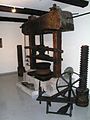
Oil mill

railway station


literature
- Le Patrimoine des Communes des Alpes-Maritimes . Flohic Editions, Volume 2, Paris 2000, ISBN 2-84234-071-X , pp. 981-982.
Web links
- Touët-sur-Var website (French)