
Utelle
| Utelle | ||
|---|---|---|

|
|
|
| region | Provence-Alpes-Cote d'Azur | |
| Department | Alpes-Maritimes | |
| Arrondissement | Nice | |
| Canton | Tourrette-Levens | |
| Community association | Nice Cote d'Azur | |
| Coordinates | 43 ° 55 ' N , 7 ° 15' E | |
| height | 126–2,080 m | |
| surface | 67.97 km 2 | |
| Residents | 873 (January 1, 2017) | |
| Population density | 13 inhabitants / km 2 | |
| Post Code | 06450 | |
| INSEE code | 06151 | |
| Website | www.mairieutelle.fr | |

Utelle is a French commune in the Alpes-Maritimes in the region Provence-Alpes-Cote d'Azur . It belongs to the Arrondissement of Nice , the Canton of Tourrette-Levens and the Métropole Nice Côte d'Azur . The residents call themselves Utellois.
geography
Utelle is located in the French Maritime Alps , it borders in the north on Venanson , in the east on Lantosque , Lucéram and Duranus , in the southeast on Levens , in the southwest on Bonson and Revest-les-Roches , in the west on Malaussène , Tournefort , Massoins and La Tour as well as clans in the northwest . The Vésubie flows through Utelle . In addition to the main settlement, the municipality also includes the hamlets of Le Blaquet, Le Chaudan, Le Cros d'Utelle, Le Figaret and Saint-Jean-la-Rivière. The Mairie is located in the latter outskirts .
Population development
| year | 1962 | 1968 | 1975 | 1982 | 1990 | 1999 | 2008 | 2012 |
|---|---|---|---|---|---|---|---|---|
| Residents | 506 | 516 | 451 | 398 | 456 | 488 | 693 | 765 |
Attractions
See: List of Monuments historiques in Utelle

Saint-Véran church was part of the Abbaye de Silvacane, which no longer exists .

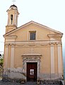
The hamlet of Le Chaudan with church
Chapelle des Pénitents blancs d'Utelle

Saint-Jean-la-Rivière: railway bridge, taken around 1930


literature
- Le Patrimoine des Communes des Alpes-Maritimes . Flohic Editions, Volume 1, Paris 2000, ISBN 2-84234-071-X , pp. 440-445.