
Signals
| Signals | ||
|---|---|---|

|
|
|
| region | Provence-Alpes-Cote d'Azur | |
| Department | Alpes-Maritimes | |
| Arrondissement | Nice | |
| Canton | Vence | |
| Community association | Alpes d'Azur | |
| Coordinates | 43 ° 52 ' N , 6 ° 58' E | |
| height | 327-1,108 m | |
| surface | 5.62 km 2 | |
| Residents | 198 (January 1, 2017) | |
| Population density | 35 inhabitants / km 2 | |
| Post Code | 06910 | |
| INSEE code | 06135 | |
 Signals |
||

Sigale is a French commune in the Alpes-Maritimes in the region Provence-Alpes-Cote d'Azur . It belongs to the Arrondissement of Nice and the Canton of Vence .
geography
The municipality is located in the French Maritime Alps and borders on Cuébris to the north, Roquestéron to the east, La Roque-en-Provence to the southeast, Aiglun to the southwest and Sallagriffon to the west .
Population development
| year | 1962 | 1968 | 1975 | 1982 | 1990 | 1999 | 2008 | 2012 |
|---|---|---|---|---|---|---|---|---|
| Residents | 138 | 112 | 155 | 145 | 160 | 181 | 210 | 210 |
Attractions
See also: List of Monuments historiques in Sigale
- Romanesque churches of Saint-Michel, built in the 13th century, monument historique
- Village fountain from 1583, Monument historique
- Notre-Dame-d'Entrevignes chapel from the 16th century
- 19th century castle with Gothic gate
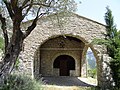
Notre-Dame-d'Entrevignes chapel
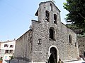
Saint-Michel church

Village fountain

Sigale against the background of the former fortress


literature
- Le Patrimoine des Communes des Alpes-Maritimes . Flohic Editions, Volume 2, Paris 2000, ISBN 2-84234-071-X , pp. 776-779.
Web links
Commons : Sigale - collection of images, videos and audio files