
Saint-Sauveur-sur-Tinée
| Saint-Sauveur-sur-Tinée | ||
|---|---|---|
.svg)
|
|
|
| region | Provence-Alpes-Cote d'Azur | |
| Department | Alpes-Maritimes | |
| Arrondissement | Nice | |
| Canton | Tourrette-Levens | |
| Community association | Nice Cote d'Azur | |
| Coordinates | 44 ° 5 ' N , 7 ° 6' E | |
| height | 432–2,708 m | |
| surface | 32.28 km 2 | |
| Residents | 308 (January 1, 2017) | |
| Population density | 10 inhabitants / km 2 | |
| Post Code | 06420 | |
| INSEE code | 06129 | |
| Website | www.saintsauveursurtinee.fr | |
 Saint-Sauveur-sur-Tinée with the Tinée |
||

Saint-Sauveur-sur-Tinée is a French commune in the Alpes-Maritimes in the region Provence-Alpes-Cote d'Azur . It belongs to the Arrondissement of Nice and the canton of Tourrette-Levens . The municipality is also a member of the Métropole Nice Côte d'Azur municipal association . The residents call themselves Sansavornins.
geography
Saint-Sauveur-sur-Tinée is located in the French Maritime Alps on the Tinée River and borders
- in the north at Isola ,
- in the northeast at Valdeblore ,
- to the east at Rimplas ,
- in the south to Ilonse ,
- to the west with Roure .
Population development
| year | 1962 | 1968 | 1975 | 1982 | 1990 | 1999 | 2008 | 2016 |
|---|---|---|---|---|---|---|---|---|
| Residents | 474 | 436 | 386 | 368 | 337 | 337 | 339 | 323 |
Attractions
See: List of Monuments historiques in Saint-Sauveur-sur-Tinée
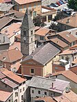
Aerial view of the Saint-Michel church
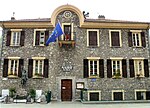
Mairie (Town Hall)


literature
- Le Patrimoine des Communes des Alpes-Maritimes . Flohic Editions, Volume 2, Paris 2000, ISBN 2-84234-071-X , pp. 866-867.
Web links
Commons : Saint-Sauveur-sur-Tinée - Collection of images, videos and audio files