
Verdon Gorge

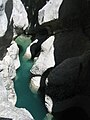
The Verdon Gorge , in French Gorges du Verdon , colloquially also Grand Canyon du Verdon , is a gorge in the French Provence , Alpes-de-Haute-Provence department . It begins downstream to the town of Castellane and ends near Moustiers-Sainte-Marie in the Lac de Sainte-Croix reservoir . The turquoise Verdon River flows through the approximately 21 km long and up to 700 meters deep canyon . The Gorges du Verdon, along with the Tara Gorge, are one of the largest canyons in Europe and a major part of the Verdon Regional Nature Park named after him .
Geographical location
The Verdon rises near the Col d'Allos in the Trois Évêchés mountains and flows into the Durance after about 175 km near Vinon-sur-Verdon . The most interesting part of its course is between Castellane and the Galetas bridge just before the Lac de Sainte-Croix . The gorge of Verdon defined over long distances, the border between the departments of Var in the south and Alpes-de-Haute-Provence in the North. The area is divided into three sections:

- The "Prégorges" between Castellane and the bridge at Soleils
- The gorge between the bridge and l'Imbut
- The canyon between l'Imbut and the Galetas bridge
The gorge is between 6 and 100 m wide at the bottom, the opposite flanks are between 200 and 1500 m apart and the depth varies between 250 and 700 m.
Emergence
During the Triassic period , Provence sank and was covered by the sea. As a result, various layers of lime (dead mussels, etc.) were deposited on the bottom. In the Jura , Provence was again flooded by a warm, shallow sea, which encouraged the formation of mighty coral banks.
In the Cretaceous the Provence rose and the sea retreated into what is now the Alps . The Alps were not unfolded until the Tertiary . The subsequently breaking limestone massifs from the Jurassic period determined the relief and the valleys. During this time the Verdon also looked for his bed.
In the Quaternary the Ice Age glaciers shaped the landscape. At the end of the glaciation, the rivers resume their erosion activity . Due to the melting of the ice, the amount of water was enormous: up to 3000 m³ / s. These quantities enabled the deep cuts in the soft rock.
Younger story
In the area of today's reservoir, which was created by the construction of the Sainte-Croix dam , was the village of Les Salles-sur-Verdon before 1973 , which was completely destroyed shortly before the valley was flooded and rebuilt elsewhere. Today it is one of the youngest parishes in France.
The gorge has been an official nature reserve since May 7, 1990 .
On July 10, 2006, the Conseil d'État decided that the planned 400,000-volt high-voltage line for the Électricité de France through the canyon could not be built. This ended a 23-year struggle between various environmental and nature conservation organizations that are committed to preserving the original gorge.
- 1905: First complete crossing of the gorge by the speleologist Martel
- 1929: The foundation stone of the Castillon dam is laid
- 1932: Construction work is interrupted
- 1936: A fire damages the dam
- 1948: Completion of the Castillon dam
- 1951: Completion of the Chaudanne dam
- 1960: completion of the Esparron-Gréoux dam
- 1973: Flooding of the Sainte-Croix reservoir
- 1973: Reconstruction of the flooded village of Les Salles-sur-Verdon about 400 m away
- 1974: Start of electricity production at the hydropower plant in Sainte-Croix
- 1975: Flooding of the Quinson reservoir
activities
On the water
Sometimes the Verdon Gorge can be navigated with white water kayaks, in the lower reaches of the Lac de Sainte-Croix even with normal rowing boats. The water runoff of the upper reservoirs is set uniformly at least during the main tourist season of July and August. In order to support water sports such as white water swimming , rafting, etc., more water is drained off two days a week (mostly Tuesdays and Fridays). The discharge is then 10-16 cubic meters of water per second, on the other days approx. 0.5 cubic meters of water per second. There is a hotline for information about current water levels. In the off-season, on the other hand, water is drained much more irregularly, in some years up to 40 cubic meters per second for weeks, in others only 0.5 cubic meters per second for weeks. With water volumes over 2 to 3 cubic meters, inexperienced swimming in white water swimming in the current is not recommended. Unpredictable obstacles such as siphons, sinks and blocks of wood can then be fatal.
hike
Hiking in the more inaccessible regions of the gorge is very popular and is considered safe. The most famous hiking route through the Verdon Canyon begins and ends in the middle of the canyon at a viewpoint from which it goes downhill relatively steeply over serpentines . It leads along the Sentier Martel (named after the Martel who first crossed it ). The descent begins from the Route de Crête, at the club house "La Maline". Once at the bottom of the river, you should stick to the fork in the road to the north and quickly follow the path upstream. In the course of the almost six-hour hike - without the possibility of an intermediate exit - the hiking trail leads steadily uphill and downhill and down some man-made ladders and stairs. One of them (Brèche Imbert) is quite steep and leads down 252 steps from a lookout point. Shortly before the end of the route, the path leads through two tunnels one behind the other, which are the only way to continue. Originally the river was supposed to be diverted completely here, but the project was abandoned after the Second World War. The length of the first tunnel is 110 m, that of the second 657 m.
A total of around five to six hours of pure walking time can be expected for this mountain hike. There is another parking lot at the end or starting point of Point Sublime in the north. For the return journey to the starting point there is the possibility of using a gorge taxi or a regular bus, which is rarely used.
Climb
The Verdon Gorge was one of the most important climbing areas in the 1970s and 1980s. In the 1970s, numerous exposed technical lines were first climbed, in the 1980s climbers such as Patrick Berhault and Patrick Edlinger managed to free many of these routes. Even today there is still intensive climbing in the area.
further activities
On the ring road around the Verdon Canyon there are viewpoints to the gorge, but also to the lavender fields for which the region is famous. Paragliders , hang- gliders and glider pilots often circle over the gorge if the weather permits. The Pont de l'Artuby is very popular with bungee jumpers . The gorge with its passes is also a destination for many motorcyclists.
gallery

View from the hiking trail

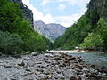
At the bottom of the gorge

View from the hiking trail

Gorge with a viewpoint

Sainte-Croix dam

Chaulière Bridge over the Artuby
The "Styx"
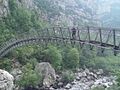
Estellié pedestrian bridge
The Imbert staircase with 6 sections and 252 steps
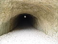
Entrance to the Trescaïre tunnel

The Artuby flows into the Verdon at Mescla
Baumes-Fères beach

Baume-aux-Pigeons

Lac de Chaudanne

Griffon vulture over the Verdon Gorge

Panoramic view over the Verdon Gorge


Individual evidence
- ↑ Eliane Patriarca: Le Verdon sauvé des volts (French) , libération.fr. Archived from the original on August 5, 2012. Retrieved March 17, 2007.
- ^ Stefan Ardito: The conquest of the giants, Bucher, Munich 2000, ISBN 3-7658-1258-7 ; P. 302 f
- ↑ Information about climbing in the Verdon Gorge ( Memento of May 16, 2011 in the Internet Archive ) in English; Retrieved July 21, 2010
Web links
Coordinates: 43 ° 44 ′ 16 ″ N , 6 ° 21 ′ 50 ″ E