
La Palud-sur-Verdon
| La Palud-sur-Verdon | ||
|---|---|---|

|
|
|
| region | Provence-Alpes-Cote d'Azur | |
| Department | Alpes-de-Haute-Provence | |
| Arrondissement | Castellane | |
| Canton | Riez | |
| Community association | Alpes Provence Verdon | |
| Coordinates | 43 ° 47 ' N , 6 ° 21' E | |
| height | 471-1,920 m | |
| surface | 81.26 km 2 | |
| Residents | 349 (January 1, 2017) | |
| Population density | 4 inhabitants / km 2 | |
| Post Code | 04120 | |
| INSEE code | 04144 | |
 La Palud-sur-Verdon |
||

La Palud-sur-Verdon is a french commune with 349 inhabitants (at January 1, 2017) in the department of Alpes-de-Haute-Provence in the region Provence-Alpes-Cote d'Azur . It belongs to the arrondissement of Castellane and the canton of Riez . The neighboring municipalities are Blieux in the northeast, Rougon in the east, Aiguines in the south, Moustiers-Sainte-Marie in the west and Majastres in the northwest.
Population development
| year | 1962 | 1968 | 1975 | 1982 | 1990 | 1999 | 2007 | 2012 |
|---|---|---|---|---|---|---|---|---|
| Residents | 154 | 141 | 152 | 172 | 243 | 297 | 314 | 329 |
Attractions
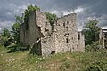
- Palud-sur-Verdon Castle, Monument historique
- Notre-Dame-de-Vauvert Church, Monument historique

Palud-sur-Verdon castle
Châteauneuf-lès-Moustiers, ruins of a village abandoned at the beginning of the 20th century

Notre-Dame-de-Vauvert church


_01.JPG)
Web links
Commons : La Palud-sur-Verdon - Collection of images, videos and audio files