
La Garde (Alpes-de-Haute-Provence)
| La Garde | ||
|---|---|---|

|
|
|
| region | Provence-Alpes-Cote d'Azur | |
| Department | Alpes-de-Haute-Provence | |
| Arrondissement | Castellane | |
| Canton | Castellane | |
| Community association | Alpes Provence Verdon | |
| Coordinates | 43 ° 50 ' N , 6 ° 33' E | |
| height | 777-1,894 m | |
| surface | 16.63 km 2 | |
| Residents | 89 (January 1, 2017) | |
| Population density | 5 inhabitants / km 2 | |
| Post Code | 04120 | |
| INSEE code | 04092 | |
,_le_village_et_le_Rocher_Saint-Martin.jpg) La Garde with the Rocher Saint-Martin |
||

La Garde is a French municipality with 89 inhabitants (at January 1, 2017) in the Alpes-de-Haute-Provence in the region Provence-Alpes-Cote d'Azur . It belongs to the canton of Castellane in the arrondissement of Castellane . The residents call themselves the Gardois .
geography
The neighboring municipalities are Demandolx in the north, Soleilhas (point of contact) in the northeast, Peyroules in the east, Châteauvieux in the southeast and Castellane in the south and west. Approximately 630 hectares of the parish mark are forested.
Surveys
- Destourbes, 1543 m to the west
- La Colline de Sebet, 1238 m to the south
- La crête du Teillon, 1893 m to the east
- La crête de Rus culmine, 1481 m , 1481 m
Population development
| year | 1962 | 1968 | 1975 | 1982 | 1990 | 1999 | 2008 | 2016 |
|---|---|---|---|---|---|---|---|---|
| Residents | 68 | 54 | 65 | 68 | 88 | 56 | 89 | 75 |
Attractions
- Notre-Dame-des-Ormeaux church
- Saint-Martin chapel
- Saint-Sébastien Chapel
- Chapel of Sainte-Anne
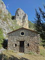
North-west facade of the Saint-Martin chapel

South-east facade of the Saint-Sébastien chapel

South facade of the Sainte-Anne chapel
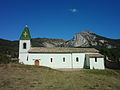
South facade of the Notre-Dame-des-Ormeaux church
,_chapelle_Saint-Martin,_fa%C3%A7ade_nord-ouest.jpg)
,_chapelle_Saint-S%C3%A9bastien,_fa%C3%A7ade_sud-est.jpg)
,_chapelle_Sainte-Anne,_fa%C3%A7ade_sud.jpg)
,_%C3%A9glise_Notre-Dame-des-Ormeaux,_fa%C3%A7ade_sud.jpg)
Web links
Commons : La Garde - collection of images, videos and audio files