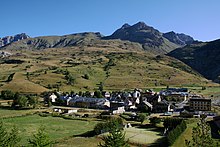
Val d'Oronaye
| Val d'Oronaye | ||
|---|---|---|
|
|
||
| region | Provence-Alpes-Cote d'Azur | |
| Department | Alpes-de-Haute-Provence | |
| Arrondissement | Barcelonnette | |
| Canton | Barcelonnette | |
| Community association | Vallée de l'Ubaye Serre-Ponçon | |
| Coordinates | 44 ° 27 ' N , 6 ° 51' E | |
| height | 1,307-3,192 m | |
| surface | 109.45 km 2 | |
| Residents | 121 (January 1, 2017) | |
| Population density | 1 inhabitant / km 2 | |
| Post Code | 04530 | |
| INSEE code | 04120 | |
Val d'Oronaye is a French commune in the Alpes-de-Haute-Provence in the region Provence-Alpes-Cote d'Azur . It belongs to the district Barcelonnette and eponymous canton of Barcelonnette . It was created with effect from January 1, 2016 as Commune nouvelle through the merger of the former municipalities Larche and Meyronnes .
structure
| District | former INSEE code |
Area (km²) | Population (2016) |
|---|---|---|---|
| Larch | 04100 | 68.86 | 57 |
| Meyronnes (administrative headquarters) | 04120 | 40.59 | 61 |
geography
The municipality borders Italy to the east . The neighboring municipalities on French territory are Jausiers , La Condamine-Châtelard , Saint-Paul-sur-Ubaye and Saint-Étienne-de-Tinée . Val d'Oronaye is connected to the national road network by Départementsstraße 900.
Web links
Commons : Val d'Oronaye - collection of images, videos and audio files
Individual evidence
- ↑ Population figures retrospectively from January 1, 2016

