
Saint-Paul-sur-Ubaye
| Saint-Paul-sur-Ubaye | ||
|---|---|---|
|
||
| region | Provence-Alpes-Cote d'Azur | |
| Department | Alpes-de-Haute-Provence | |
| Arrondissement | Barcelonnette | |
| Canton | Barcelonnette | |
| Community association | Vallée de l'Ubaye Serre-Ponçon | |
| Coordinates | 44 ° 31 ' N , 6 ° 45' E | |
| height | 1,291-3,411 m | |
| surface | 205.55 km 2 | |
| Residents | 186 (January 1, 2017) | |
| Population density | 1 inhabitant / km 2 | |
| Post Code | 04530 | |
| INSEE code | 04193 | |
 Saint-Paul-sur-Ubaye |
||

Saint-Paul-sur-Ubaye is a French municipality with 186 inhabitants (at January 1, 2017) in the department of Alpes-de-Haute-Provence in the region Provence-Alpes-Cote d'Azur . It belongs to the canton of Barcelonnette in the arrondissement of Barcelonnette .
geography
Saint-Paul-sur-Ubaye is the northernmost and easternmost commune of the Alpes-de-Haute-Provence department. It is located in the French Maritime Alps . The Ubaye rises with its numerous source streams in the district of Saint-Paul-sur-Ubaye. This borders directly on Italy in the east . The neighboring French municipalities are Val d'Oronaye and La Condamine-Châtelard in the south, Crévoux , Vars and Ceillac in the west and Saint-Veran in the north.
Population development
| 1962 | 1968 | 1975 | 1982 | 1990 | 1999 | 2008 | 2014 |
|---|---|---|---|---|---|---|---|
| 238 | 232 | 221 | 208 | 198 | 190 | 228 | 202 |
Attractions
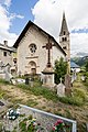
- Maurin Cemetery, Monument historique
- Saint-Antoine-du-Désert de Maurin church, Monument historique
- Saint-Pierre-et-Paul church
- Redoute de Berwick
See also: List of Monuments historiques in Saint-Paul-sur-Ubaye

Redoute de Berwick
Saint-Pierre-et-Saint-Paul church

Saint-Thomas church in the Tournoux district


