
Crévoux
| Crévoux | ||
|---|---|---|

|
|
|
| region | Provence-Alpes-Cote d'Azur | |
| Department | Hautes-Alpes | |
| Arrondissement | Gap | |
| Canton | Embrun | |
| Community association | Serre poncon | |
| Coordinates | 44 ° 33 ' N , 6 ° 36' E | |
| height | 1,169-2,989 m | |
| surface | 56.26 km 2 | |
| Residents | 130 (January 1, 2017) | |
| Population density | 2 inhabitants / km 2 | |
| Post Code | 05200 | |
| INSEE code | 05044 | |
 Mairie Crévoux |
||

Crévoux is a commune in the Hautes-Alpes in the region of Provence-Alpes-Cote d'Azur . It belongs to the Arrondissement of Gap and the Canton of Embrun . The residents call themselves Crévolins.
geography
The community is located in the French Alps , the mountain massif Massif du Parpaillon . It is bordered by Vars to the northeast, Saint-Paul-sur-Ubaye to the east, La Condamine-Châtelard to the southeast, Les Orres to the southwest, Saint-Sauveur to the west and Saint-André-d'Embrun to the northwest . The main settlement with the Mairie is called La Chalp. The hamlets of Praveyral and Champrond also belong to the municipality.
Surveys
- Pic Saint-André ( 2857 m )
- Pic des Chabrières ( 2746 m )
- Pic de Crévoux ( 2644 m )
- Pointe de l'Eyssina ( 2837 m )
- Grande Parpaillon ( 2990 m )
- L'Arete de la Ratelle ( 2572 m )
history
Earlier place names were "Crevolum" (1127) and "Crevolis" (13th century).
Population development
| year | 1962 | 1968 | 1975 | 1982 | 1990 | 1999 | 2006 | 2008 | 2012 |
|---|---|---|---|---|---|---|---|---|---|
| Residents | 159 | 131 | 127 | 115 | 117 | 103 | 124 | 129 | 134 |

Saint-Marcellin church
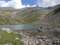
Mountain lake Lac du Crachet

