
Étoile-Saint-Cyrice
| Étoile-Saint-Cyrice | ||
|---|---|---|
|
||
| region | Provence-Alpes-Cote d'Azur | |
| Department | Hautes-Alpes | |
| Arrondissement | Gap | |
| Canton | Serres | |
| Community association | Sisteronais-Buëch | |
| Coordinates | 44 ° 19 ′ N , 5 ° 38 ′ E | |
| height | 698-1,296 m | |
| surface | 14.41 km 2 | |
| Residents | 30 (January 1, 2017) | |
| Population density | 2 inhabitants / km 2 | |
| Post Code | 05700 | |
| INSEE code | 05051 | |

Étoile-Saint-Cyrice is a commune in the Hautes-Alpes in the region of Provence-Alpes-Cote d'Azur . It belongs to the arrondissement of Gap and the canton of Serres .
geography
It is around 19 kilometers from Laragne-Montéglin and lies on the border with the neighboring Drôme department in the Auvergne-Rhône-Alpes region . It borders on the following municipalities:
- in the northwest at Montjay ,
- in the northeast at Chanousse ,
- to the east at Orpierre ,
- in the south-east at Sainte-Colombe ,
- in the southwest at Laborel (Département Drôme),
- to the west at Villebois-les-Pins (Département Drôme).
Population development
| year | 1962 | 1968 | 1975 | 1982 | 1990 | 1999 | 2008 | 2012 |
|---|---|---|---|---|---|---|---|---|
| Residents | 36 | 39 | 29 | 20th | 28 | 31 | 35 | 32 |
Attractions
- Saint-Antoine church
- Saint-Cyrice church, built in the 11th / 12th centuries. Century, Monument historique
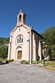
Saint-Antoine church

Saint-Cyrice Chapel


Web links
Commons : Étoile-Saint-Cyrice - Collection of images, videos and audio files