
Poligny (Hautes-Alpes)
| Poligny | ||
|---|---|---|

|
|
|
| region | Provence-Alpes-Cote d'Azur | |
| Department | Hautes-Alpes | |
| Arrondissement | Gap | |
| Canton | Saint-Bonnet-en-Champsaur | |
| Community association | Champsaur-Valgaudemar | |
| Coordinates | 44 ° 42 ' N , 6 ° 3' E | |
| height | 896–2,082 m | |
| surface | 13.81 km 2 | |
| Residents | 296 (January 1, 2017) | |
| Population density | 21 inhabitants / km 2 | |
| Post Code | 05500 | |
| INSEE code | 05104 | |
 Mairie and school in Poligny |
||

Poligny is a French municipality with 296 inhabitants (as of January 1 2017) in the Hautes-Alpes in the region of Provence-Alpes-Cote d'Azur . It belongs to the Gap arrondissement and the canton of Saint-Bonnet-en-Champsaur .
geography
In the northeast, the Drac river forms the border with Aubessagne and Saint-Bonnet-en-Champsaur with Bénévent-et-Charbillac. The Route nationale 85 runs parallel to this watercourse , combined with the Route Napoléon . The other neighboring municipalities are La Fare-en-Champsaur in the southeast, Gap in the south and Le Noyer in the west.
Population development
| year | 1962 | 1968 | 1975 | 1982 | 1990 | 1999 | 2006 | 2012 | ||
|---|---|---|---|---|---|---|---|---|---|---|
| Residents | 270 | 262 | 232 | 219 | 237 | 230 | 285 | 344 | ||
| Source: Cassini and INSEE | ||||||||||

Chapel of Villeneuve

Les Forestons, chapel
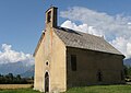
Saint-Etienne chapel
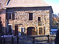
House in traditional style


Web links
Commons : Poligny - collection of images, videos and audio files