
La Saulce
| La Saulce | ||
|---|---|---|

|
|
|
| region | Provence-Alpes-Cote d'Azur | |
| Department | Hautes-Alpes | |
| Arrondissement | Gap | |
| Canton | Tallard | |
| Community association | Gap-Tallard-Durance | |
| Coordinates | 44 ° 26 ' N , 6 ° 1' E | |
| height | 555-1,046 m | |
| surface | 7.89 km 2 | |
| Residents | 1,555 (January 1, 2017) | |
| Population density | 197 inhabitants / km 2 | |
| Post Code | 05110 | |
| INSEE code | 05162 | |
 La Saulce |
||

La Saulce is a French commune in the Hautes-Alpes in the region of Provence-Alpes-Cote d'Azur . It belongs to the canton of Tallard in the Gap arrondissement .
geography
In the south and south-east the Durance forms the border with Curbans . The other neighboring municipalities are Tallard in the northeast, Lardier-et-Valença in the west and Fouillouse in the north.
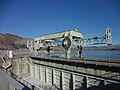
The La Saulce and Curbans weir

The Autoroute A51 at La Saulce


Population development
| year | 1962 | 1968 | 1975 | 1982 | 1990 | 1999 | 2006 | 2017 |
|---|---|---|---|---|---|---|---|---|
| Residents | 567 | 565 | 688 | 638 | 632 | 905 | 1190 | 1555 |
Web links
Commons : La Saulce - Collection of images, videos and audio files