
Saint-Michel-de-Chaillol
| Saint-Michel-de-Chaillol | ||
|---|---|---|
|
||
| region | Provence-Alpes-Cote d'Azur | |
| Department | Hautes-Alpes | |
| Arrondissement | Gap | |
| Canton | Saint-Bonnet-en-Champsaur | |
| Community association | Champsaur-Valgaudemar | |
| Coordinates | 44 ° 41 ′ N , 6 ° 10 ′ E | |
| height | 1,220–2,745 m | |
| surface | 16.78 km 2 | |
| Residents | 335 (January 1, 2017) | |
| Population density | 20 inhabitants / km 2 | |
| Post Code | 05260 | |
| INSEE code | 05153 | |
 Saint-Michel-de-Chaillol |
||

Saint-Michel-de-Chaillol is a French commune in the Hautes-Alpes in the region of Provence-Alpes-Cote d'Azur . It belongs to the Gap arrondissement and the canton of Saint-Bonnet-en-Champsaur .
geography
Saint-Michel-de-Chaillol is located in the Maritime Alps in the catchment area of the Drac River . In the north and in the east, the municipal boundary runs along a watershed . Numerous streams, including the Riou de Buissard and the Riou Mort , cross the municipality mark . The neighboring municipalities are La Motte-en-Champsaur in the north, Champoléon in the northeast, Saint-Jean-Saint-Nicolas in the east, Chabottes in the south, Buissard in the southwest, and Saint-Julien-en-Champsaur and Saint-Bonnet-en-Champsaur in the West. Elevations belonging to Saint-Michel-de-Chaillol are the Pic du Tourond ( 2745 m ) and the Pic Queyrel ( 2440 m ). The Chaillol 1600 winter sports area is located at 1500–1991 m. ü. In addition to the main settlement of Chaillol , the hamlets of Saint Michel, Les Marrons, La Villette and Chaillolet also belong to the municipality .
Population development
| year | 1962 | 1968 | 1975 | 1982 | 1990 | 1999 | 2006 | 2008 | 2016 |
|---|---|---|---|---|---|---|---|---|---|
| Residents | 231 | 232 | 253 | 316 | 336 | 301 | 328 | 334 | 324 |

Chapel in Chaillolet

Chapel in Les Marrons
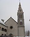
Saint-Pierre church
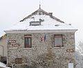
Town Hall ( Mairie )


