
Jarjayes
| Jarjayes | ||
|---|---|---|

|
|
|
| region | Provence-Alpes-Cote d'Azur | |
| Department | Hautes-Alpes | |
| Arrondissement | Gap | |
| Canton | Tallard | |
| Community association | Gap-Tallard-Durance | |
| Coordinates | 44 ° 30 ′ N , 6 ° 7 ′ E | |
| height | 586-1,310 m | |
| surface | 22.67 km 2 | |
| Residents | 450 (January 1, 2017) | |
| Population density | 20 inhabitants / km 2 | |
| Post Code | 05130 | |
| INSEE code | 05068 | |
 Jarjayes |
||

Jarjayes is a municipality in France . It belongs to the Provence-Alpes-Côte d'Azur region , the Hautes-Alpes department , the Gap arrondissement and the Tallard canton .
geography
The village center is located at 1000 m in the Maritime Alps . The municipality is bordered by Rambaud to the north, Saint-Étienne-le-Laus to the northeast, Valserres to the east, Venterol to the south, Lettret to the southwest and Gap to the northwest . In the south of Jarjayes the Avance flows into the Durance .
Population development
| year | 1962 | 1968 | 1975 | 1982 | 1990 | 1999 | 2008 | 2012 |
|---|---|---|---|---|---|---|---|---|
| Residents | 210 | 196 | 203 | 254 | 312 | 379 | 418 | 418 |
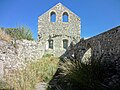
Remains of the former Saint-Thomas-Saint-Restitut church

Saint-Pierre Chapel

today's church of Saint-Thomas-Saint-Restitut


Web links
Commons : Jarjayes - collection of images, videos and audio files