
Le Noyer (Hautes-Alpes)
| Le Noyer | ||
|---|---|---|

|
|
|
| region | Provence-Alpes-Cote d'Azur | |
| Department | Hautes-Alpes | |
| Arrondissement | Gap | |
| Canton | Saint-Bonnet-en-Champsaur | |
| Community association | Champsaur-Valgaudemar | |
| Coordinates | 44 ° 42 ′ N , 6 ° 1 ′ E | |
| height | 839–2,563 m | |
| surface | 21.5 km 2 | |
| Residents | 292 (January 1, 2017) | |
| Population density | 14 inhabitants / km 2 | |
| Post Code | 05500 | |
| INSEE code | 05095 | |

Le Noyer is a French municipality with 292 inhabitants (as of January 1 2017) in the Hautes-Alpes in the region of Provence-Alpes-Cote d'Azur . It belongs to the Gap arrondissement and the canton of Saint-Bonnet-en-Champsaur .
geography
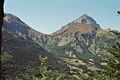
Le Noyer is located in the area of the Massif des Écrins in the Maritime Alps . In the northeast, the Drac River forms the border with Aubessagne . The other neighboring communities are Poligny in the southeast, Gap in the south, Dévoluy with the district of Saint-Étienne-en-Dévoluy in the west and Le Glaizil in the northwest.
Population development
| year | 1962 | 1968 | 1975 | 1982 | 1990 | 1999 | 2008 | 2016 |
|---|---|---|---|---|---|---|---|---|
| Residents | 289 | 263 | 219 | 215 | 243 | 222 | 257 | 290 |
Col du Noyer

“Refuge Napoléon”, restaurant on the Col du Noyer

Mairie and school


Web links
Commons : Le Noyer - collection of images, videos and audio files