
Le Glaizil
| Le Glaizil | ||
|---|---|---|

|
|
|
| region | Provence-Alpes-Cote d'Azur | |
| Department | Hautes-Alpes | |
| Arrondissement | Gap | |
| Canton | Saint-Bonnet-en-Champsaur | |
| Community association | Champsaur-Valgaudemar | |
| Coordinates | 44 ° 45 ′ N , 5 ° 59 ′ E | |
| height | 774–2,570 m | |
| surface | 21.93 km 2 | |
| Residents | 166 (January 1, 2017) | |
| Population density | 8 inhabitants / km 2 | |
| Post Code | 05800 | |
| INSEE code | 05062 | |

Le Glaizil is a French commune in the Hautes-Alpes in the region of Provence-Alpes-Cote d'Azur . It belongs to the Gap arrondissement and the canton of Saint-Bonnet-en-Champsaur .
geography
La Glaizil is located in the French Maritime Alps . The neighboring municipalities are Beaufin in the north, Saint-Firmin in the northeast, Aubessagne in the east, Le Noyer in the south, Dévoluy in the west and Monestier-d'Ambel in the northwest.
Population development
| year | 1962 | 1968 | 1975 | 1982 | 1990 | 1999 | 2006 | 2012 |
|---|---|---|---|---|---|---|---|---|
| Residents | 195 | 155 | 168 | 175 | 169 | 179 | 166 | 180 |
Attractions
- Château de Lesdiguières, castle ruins , monument historique

Remains of the Château de Lesdiguières
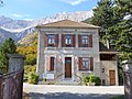
town hall
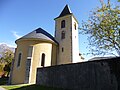
Saint-Jacques and Saint-Ambroise church

War memorial


Web links
Commons : Le Glaizil - collection of images, videos and audio files