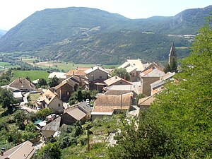
Avançon (Hautes-Alpes)
| Avancon | ||
|---|---|---|

|
|
|
| region | Provence-Alpes-Cote d'Azur | |
| Department | Hautes-Alpes | |
| Arrondissement | Gap | |
| Canton | Tallard | |
| Community association | Serre-Ponçon Val d'Avance | |
| Coordinates | 44 ° 32 ' N , 6 ° 11' E | |
| height | 718-1,629 m | |
| surface | 22.57 km 2 | |
| Residents | 404 (January 1, 2017) | |
| Population density | 18 inhabitants / km 2 | |
| Post Code | 05230 | |
| INSEE code | 05011 | |
 Avancon |
||
Avançon is a French commune in the Hautes-Alpes in the region of Provence-Alpes-Cote d'Azur . It belongs to the Gap arrondissement and the Tallard canton .
geography
The Avance flows through Avançon . The village is eight kilometers from La Bâtie-Neuve , 13 kilometers from Chorges , 16 kilometers from Tallard and 20 kilometers from Gap . The municipality is bordered by La Bâtie-Neuve to the north, Montgardin to the east, Espinasses to the southeast, Théus to the south, Saint-Étienne-le-Laus to the southwest and La Bâtie-Vieille to the west . In addition to the main settlement, Avançon also includes the hamlet of Santons. Part of the 1734 m high Mont Collombis belongs to Avançon.
Attractions
- Church from 1655
- Saint-Gervais chapel, restored in 1980
Population development
| year | 1962 | 1968 | 1975 | 1982 | 1990 | 1999 | 2006 | 2013 |
|---|---|---|---|---|---|---|---|---|
| Residents | 249 | 252 | 219 | 261 | 279 | 330 | 350 | 404 |
Web links
Commons : Avançon - collection of images, videos and audio files
