La Roche-des-Arnauds
| La Roche-des-Arnauds | ||
|---|---|---|

|
|
|
| region | Provence-Alpes-Cote d'Azur | |
| Department | Hautes-Alpes | |
| Arrondissement | Gap | |
| Canton | Veynes | |
| Community association | Buëch-Dévoluy | |
| Coordinates | 44 ° 34 ' N , 5 ° 57' E | |
| height | 885–2,709 m | |
| surface | 53.75 km 2 | |
| Residents | 1,521 (January 1, 2017) | |
| Population density | 28 inhabitants / km 2 | |
| Post Code | 05400 | |
| INSEE code | 05123 | |
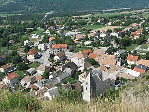
 Place view |
||
La Roche-des-Arnauds is a French commune in the Hautes-Alpes in the region of Provence-Alpes-Cote d'Azur . It belongs to the canton of Veynes in the Gap arrondissement .
geography
The white water river Petit Buëch comes from Rabou , follows the border with Manteyer in the southwest and then flows to Montmaur . A right tributary is the Béal de Pré le Bayle, which flows through a reservoir in La Roche-des-Arnauds . The neighboring communities are
- Dévoluy with Saint-Étienne-en-Dévoluy in the north,
- Rabou and Gap in the east,
- La Freissinouse in the southeast,
- Manteyer in the south,
- Montmaur to the west.
Population development
| year | 1962 | 1968 | 1975 | 1982 | 1990 | 1999 | 2008 | 2012 |
|---|---|---|---|---|---|---|---|---|
| Residents | 670 | 607 | 678 | 763 | 845 | 953 | 1,347 | 1,449 |
Web links
Commons : La Roche-des-Arnauds - collection of images, videos and audio files


