
Rochebrune (Hautes-Alpes)
| Rochebrune | ||
|---|---|---|

|
|
|
| region | Provence-Alpes-Cote d'Azur | |
| Department | Hautes-Alpes | |
| Arrondissement | Gap | |
| Canton | Chorges | |
| Community association | Serre-Ponçon Val d'Avance | |
| Coordinates | 44 ° 27 ' N , 6 ° 11' E | |
| height | 622-1,374 m | |
| surface | 12.37 km 2 | |
| Residents | 171 (January 1, 2017) | |
| Population density | 14 inhabitants / km 2 | |
| Post Code | 05190 | |
| INSEE code | 05121 | |
.JPG) Rochebrune |
||

Rochebrune is a French commune in the Hautes-Alpes in the region of Provence-Alpes-Cote d'Azur . It belongs to the Arrondissement of Gap and the Canton of Chorges .
geography
The neighboring communities are:
- Remollon , Théus and Espinasses in the north,
- Rousset (point of contact) in the northeast,
- Ubaye-Serre-Ponçon with La Bréole in the east,
- Bréziers in the south,
- Bellaffaire and Gigors in the southwest,
- Piégut in the west.
In the north, Rochebrune is touched by the Durance river . The Canal de Curban runs parallel to the natural flowing water and begins at a stream called Torrent de Clapouse and leads east to one of the three lakes Lac du plan d'eau .
Population development
| year | 1962 | 1968 | 1975 | 1982 | 1990 | 1999 | 2008 | 2012 |
|---|---|---|---|---|---|---|---|---|
| Residents | 134 | 78 | 94 | 106 | 99 | 128 | 148 | 171 |

Canal de Curban

War memorial
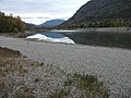
Lake No. 1 of the Plan d'eau les 3 Lacs


Web links
Commons : Rochebrune - collection of images, videos and audio files