
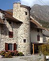
La Motte-en-Champsaur
| La Motte-en-Champsaur | ||
|---|---|---|

|
|
|
| region | Provence-Alpes-Cote d'Azur | |
| Department | Hautes-Alpes | |
| Arrondissement | Gap | |
| Canton | Saint-Bonnet-en-Champsaur | |
| Community association | Champsaur-Valgaudemar | |
| Coordinates | 44 ° 44 ′ N , 6 ° 4 ′ E | |
| height | 1,014-3,163 m | |
| surface | 52.8 km 2 | |
| Residents | 217 (January 1, 2017) | |
| Population density | 4 inhabitants / km 2 | |
| Post Code | 05500 | |
| INSEE code | 05090 | |
 La Motte-en-Champsaur |
||

La Motte-en-Champsaur is a French municipality with 217 inhabitants (as of January 1 2017) in the Hautes-Alpes in the region of Provence-Alpes-Cote d'Azur . It belongs to the Gap arrondissement and the canton of Saint-Bonnet-en-Champsaur .
geography
The summit of the Vieux Chaillol at 3,163 m is the highest point in the municipality. La Motte-en-Champsaur borders in the north on Saint-Maurice-en-Valgodemard , in the northeast on La Chapelle-en-Valgaudémar , in the east on Champoléon , in the south on Saint-Michel-de-Chaillol and Saint-Bonnet-en- Champsaur , to the west and south-west on Aubessagne and to the north-west on Saint-Jacques-en-Valgodemard .
history
In 1931 the previously independent village of Molines was incorporated.
Population development
| year | 1962 | 1968 | 1975 | 1982 | 1990 | 1999 | 2008 | 2012 |
|---|---|---|---|---|---|---|---|---|
| Residents | 222 | 182 | 151 | 167 | 155 | 177 | 185 | 227 |
| Source: Cassini and INSEE | ||||||||

Molines-en-Champsaur chapel

Saint-Sauveur church
Pigeon tower


