
Manteyer
| Manteyer | ||
|---|---|---|

|
|
|
| region | Provence-Alpes-Cote d'Azur | |
| Department | Hautes-Alpes | |
| Arrondissement | Gap | |
| Canton | Veynes | |
| Community association | Buëch-Dévoluy | |
| Coordinates | 44 ° 32 ' N , 5 ° 58' E | |
| height | 890-1,974 m | |
| surface | 25.63 km 2 | |
| Residents | 429 (January 1, 2017) | |
| Population density | 17 inhabitants / km 2 | |
| Post Code | 05400 | |
| INSEE code | 05075 | |
 Mairie Manteyer |
||

Manteyer is a French commune in the Hautes-Alpes in the region of Provence-Alpes-Cote d'Azur . It belongs to the canton of Veynes in the Gap arrondissement .
geography
The mountain river Petit Buëch flows in the northwest along the municipal boundary. The neighboring municipalities of Manteyer are La Roche-des-Arnauds in the north, La Freissinouse in the east, Pelleautier in the southeast, Châteauneuf-d'Oze in the southwest and Montmaur in the west.
Population development
| year | 1962 | 1968 | 1975 | 1982 | 1990 | 1999 | 2008 | 2012 |
|---|---|---|---|---|---|---|---|---|
| Residents | 207 | 200 | 178 | 211 | 222 | 305 | 414 | 423 |
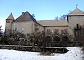
Castle of Manteyer

Saint-Roch church


Web links
Commons : Manteyer - collection of images, videos and audio files