
La Bâtie-Neuve
| La Bâtie-Neuve | ||
|---|---|---|

|
|
|
| region | Provence-Alpes-Cote d'Azur | |
| Department | Hautes-Alpes | |
| Arrondissement | Gap | |
| Canton | Chorges | |
| Community association | Serre-Ponçon Val d'Avance | |
| Coordinates | 44 ° 34 ' N , 6 ° 12' E | |
| height | 824–2,420 m | |
| surface | 27.99 km 2 | |
| Residents | 2,534 (January 1, 2017) | |
| Population density | 91 inhabitants / km 2 | |
| Post Code | 05230 | |
| INSEE code | 05017 | |
 The Mairie |
||

La Batie-Neuve is a French commune in the Hautes-Alpes in the region of Provence-Alpes-Cote d'Azur . It belongs to the canton of Chorges in the Gap arrondissement .
geography
La Batie-Neuve is located ten kilometers from Gap located in the mountain massif Massif des Écrins in the Maritime Alps . The neighboring communities are:
- Ancelle in the north,
- Chorges in the east,
- Montgardin and Avançon in the south,
- La Bâtie-Vieille in the southwest,
- La Rochette to the west.
Population development
| year | 1962 | 1968 | 1975 | 1982 | 1990 | 1999 | 2006 | 2011 | 2012 |
|---|---|---|---|---|---|---|---|---|---|
| Residents | 528 | 510 | 627 | 837 | 1,327 | 1,687 | 1,976 | 2,431 | 2,420 |
Attractions
- A tower that belonged to a castle that no longer exists today
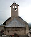
- The pastoral church of Notre-Dame-de-Consolation, built in the 16./17. century

The Bâtie-Neuve train station
The Saint-Pancrace chapel


Web links
Commons : La Bâtie-Neuve - Collection of images, videos and audio files