Savines-le-Lac
| Savines-le-Lac | ||
|---|---|---|

|
|
|
| region | Provence-Alpes-Cote d'Azur | |
| Department | Hautes-Alpes | |
| Arrondissement | Gap | |
| Canton | Chorges | |
| Community association | Serre poncon | |
| Coordinates | 44 ° 32 ' N , 6 ° 24' E | |
| height | 775-2,260 m | |
| surface | 25.13 km 2 | |
| Residents | 1,058 (January 1, 2017) | |
| Population density | 42 inhabitants / km 2 | |
| Post Code | 05160 | |
| INSEE code | 05164 | |
| Website | www.savines-le-lac.fr | |
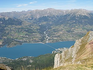
 Savines-le-Lac with the Lac de Serre-Ponçon |
||
Savines-le-Lac is a French commune in the Hautes-Alpes in the region of Provence-Alpes-Cote d'Azur . It belongs to the canton of Chorges in the Gap arrondissement .
geography
The municipality lies on both sides of the Lac de Serre-Ponçon reservoir , which dams the upper Durance . Route nationale 94 , which connects the two shores of the lake via the Pont de Savines , runs through the village . Several mountain rivers and streams flow into the lake in the municipality. They are:
- coming from the north
- Torrent de Riou Bourdoux (7 km)
- Torrent de Réallon (20 km)
- coming from the south:
- Torrent de Biaret (5 km)
- Torrent de Barnafret (5 km)
Neighboring communities are:
- in the north of Réallon ,
- in the northeast of Puy-Sanières ,
- in the southeast of Crot ,
- in the southwest of Pontis ,
- in the west of Prunières ,
- to the northwest of Saint-Apollinaire .
Pont de Savines over the Lac de Serre-Ponçon
Population development
| year | 1962 | 1968 | 1975 | 1982 | 1990 | 1999 | 2008 | 2012 |
|---|---|---|---|---|---|---|---|---|
| Residents | 408 | 589 | 663 | 790 | 759 | 815 | 1,136 | 1,068 |
Community partnerships
Savine's partner municipality is Luserna San Giovanni in the Italian region of Piedmont.
Web links
Commons : Savines-le-Lac - collection of images, videos and audio files


