
Lac de Serre-Ponçon
| Lac de Serre-Ponçon | |||||
|---|---|---|---|---|---|
 |
|||||
|
|||||
|
|||||
| Coordinates | 44 ° 31 '1 " N , 6 ° 20' 53" E | ||||
| Data on the structure | |||||
| Construction time: | 1955-1961 | ||||
| Height of the barrier structure : | 124 m | ||||
| Building volume: | 14.1 million m³ | ||||
| Crown length: | 630 m | ||||
| Crown width: | 9.35 m | ||||
| Power plant output: | 380 MW | ||||
| Data on the reservoir | |||||
| Altitude (at congestion destination ) | 785 m | ||||
| Water surface | 29 km² | ||||
| Reservoir length | 20 km | ||||
| Storage space | 1.2 km³ | ||||
| Catchment area | 3 600 km² | ||||
| Design flood : | 2 500 m³ / s | ||||

The Lac de Serre-Ponçon is a reservoir in the French Western Alps in the departments of Hautes-Alpes and Alpes-de-Haute-Provence .
dam
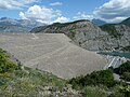
Its 124 m high and 630 m long dam, built between 1955 and 1961, dams the upper Durance . Europe's largest earth dam is 123 m thick at its base and contains over 14 million cubic meters of material. Before the sea flooding, 1,500 people had to be resettled. In addition, the Veynes – Briançon line and two national roads (N94 and N100) were relocated. The unfinished Chorges – Barcelonnette railway line was flooded over a length of 10 kilometers. Some bridges, including the pillars of the 70 m high bridge over the Durance, were blown up. The Chanteloube Viaduct was preserved and can be accessed at low tide. The Pont de Savines crossing the lake was built to connect the newly created Savines-le-Lac to the laid N94.
Power generation
The 20 km long and maximally 120 m deep reservoir has a water capacity of 1.2 billion cubic meters and covers an area of 29 square kilometers . Its main purpose is to generate electricity . The underground power station has a standard capacity of annually about 700 million kilowatt hours , representing 10 percent of France from hydropower gained energy represents 100% of the energy requirements of the department of Hautes-Alpes equivalent. There are further power stations downstream, which are also powered by the lake water via a canal .
Flood protection
In addition, the dam is used for flood protection and the reservoir for irrigation and drinking water supply. The first ideas for building a flood-regulating dam on the Durance matured after the catastrophic floods that hit the lower reaches of the Avignon area in particular in 1843 and 1856 .
The dam usually reaches its storage destination after the snow has melted in late spring and early summer (May / June). From then on, the water level is continuously lowered through irrigation and industrial use and reaches its lowest level at the end of winter (February, March).
Other use
The Lac de Serre-Ponçon is used intensively for tourism.
On the north bank, near the Roustou campsite , stands the Saint-Michel chapel on a small hill. Originally it was supposed to be demolished in the course of the construction of the dam, but this was not done because it is above the maximum expected water level. When the water level is low, it can be reached on foot from the shore; when the water level is high, the hill forms a small island in the lake.

Lac de Serre-Ponçon, at the end of the lake the dam
The dam

Course of the railway lines before and after the impoundment

Saint-Michel chapel at low tide


Web links
- SMADESEP (Syndicat Mixte d'Aménagement et de Développement de Serre-Ponçon), administrative organization for tourism promotion on the lake (website contains under Le lac de Serre-Ponçon representation of the motives and history of the dam construction with videos)
- Lac de Serre-poncon: forum, photos, niveau du lac, météo ...
- Lac de Serre-Poncon et le village de Savines-le-lac
- Annuaire de site du Lac de Serre-Ponçon
- Lac de Serre-Ponçon et hautes-alpes
- Pictures from the Lac de Serre-Ponçon near Embrun
Individual evidence
- ↑ a b Source: EDF information board
- ↑ La construction du barrage on the SMADESEP website