Ubaye
| Ubaye | ||
|
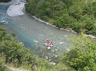
The river between Les Thuiles and Le Lauzet-Ubaye |
||
| Data | ||
| Water code | FR : X04-0400 | |
| location | France , Provence-Alpes-Cote d'Azur region | |
| River system | Rhône | |
| Drain over | Durance → Rhône → Mediterranean | |
| source | in the municipality of Saint-Paul-sur-Ubaye 44 ° 37 ′ 31 ″ N , 6 ° 57 ′ 41 ″ E |
|
| Source height | approx. 2965 m | |
| muzzle | on the municipal boundary of Le Sauze-du-Lac and La Bréole in the Durance coordinates: 44 ° 28 ′ 36 " N , 6 ° 17 ′ 49" E, 44 ° 28 ′ 36 " N , 6 ° 17 ′ 49" E |
|
| Mouth height | approx. 780 m | |
| Height difference | approx. 2185 m | |
| Bottom slope | approx. 26 ‰ | |
| length | 83 km | |
| Catchment area | 1011 km² | |
| Discharge at the gauge Lauzet-Ubaye A Eo : 946 km² |
MQ Mq |
21 m³ / s 22.2 l / (s km²) |
| Left tributaries | Ubayette , Torrent d'Abriès , Riou Versant, Bachelard , Grand Riou de la Blanche | |
| Right tributaries | Parpaillon | |
| Flowing lakes | Lac de Longet | |
The Ubaye is a mountain river in France that runs in the Provence-Alpes-Côte d'Azur region . It rises in the French part of the Cottian Alps , near the Italian border, at the Col du Loup in the municipality of Saint-Paul-sur-Ubaye . It drains with a steep gradient towards southwest to west and flows after 83 kilometers at the municipal border of Le Sauze-du-Lac and La Bréole in the backwater of Lac de Serre-Ponçon as a left tributary into the Durance . On its way, the Ubaye crosses the Alpes-de-Haute-Provence department and for the last three kilometers forms the border with the neighboring Hautes-Alpes department .
Places on the river
(Order in flow direction)
- Saint-Paul-sur-Ubaye
- La Condamine-Châtelard
- Jausiers
- Barcelonnette
- Les Thuiles
- Méolans-Revel
- Le Lauzet-Ubaye
- Le Sauze-du-Lac
tourism
The Ubaye is a white water river on which canoeing and rafting are practiced. The level of difficulty changes significantly in the different sections. In the upper part to Les Thuiles the difficulties are moderate. Then these increase significantly and increase in a short steep section between La Fresquière and Le Martinet up to the upper range of the whitewater difficulty scale . Then the difficulties decrease somewhat and then increase considerably from Le Lauzet-Ubaye in the Royal Gorge to the edge of the accessibility.
Winter sports are practiced in the mountains of the upper reaches.
Web links
Individual evidence
- ↑ Source geoportail.gouv.fr
- ↑ estuary geoportail.gouv.fr
- ↑ a b Water information system Service d'Administration National des Données et Référentiels sur l'Eau (French) ( information ), accessed on February 23, 2015, rounded to full kilometers
- ↑ hydro.eaufrance.fr (station: X0454010 , option: Synthèse ) .
