
Méolans-Revel
| Méolans-Revel | ||
|---|---|---|
|
||
| region | Provence-Alpes-Cote d'Azur | |
| Department | Alpes-de-Haute-Provence | |
| Arrondissement | Barcelonnette | |
| Canton | Barcelonnette | |
| Community association | Vallée de l'Ubaye Serre-Ponçon | |
| Coordinates | 44 ° 24 ' N , 6 ° 31' E | |
| height | 912-2,928 m | |
| surface | 127.74 km 2 | |
| Residents | 339 (January 1, 2017) | |
| Population density | 3 inhabitants / km 2 | |
| Post Code | 04340 | |
| INSEE code | 04161 | |

Méolans-Revel is a French municipality with 339 inhabitants (at January 1, 2017) in the department of Alpes-de-Haute-Provence in the region Provence-Alpes-Cote d'Azur . It belongs to the arrondissement of Barcelonnette and the canton of Barcelonnette .
geography
Méolans-Revel is located in the French Maritime Alps , around ten kilometers from Le Lauzet-Ubaye and twelve kilometers from Barcelonnette . She borders
- to the north at Crots and Les Orres ,
- in the northeast at Saint-Pons (point of contact),
- to the east at Les Thuiles and Uvernet-Fours ,
- in the southeast at Allos ,
- in the south on Prads-Haute-Bléone ,
- in the southwest at Le Vernet and Seyne ,
- to the northwest at Le Lauzet-Ubaye .
The municipality is crossed by the Ubaye river and is made up of the villages of Méolans, Revel, Laverq and other hamlets.
Surveys
- Tete de l'Estrop, 2961 m
- Trois-Évêchés, 2819 m
- Grande Séolane, 2909 m
- Petite Séolane, 2855 m
Population development
| year | 1962 | 1968 | 1975 | 1982 | 1990 | 1999 | 2008 | 2012 |
|---|---|---|---|---|---|---|---|---|
| Residents | 358 | 299 | 230 | 224 | 227 | 284 | 330 | 333 |
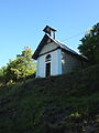
Chapel of Sainte-Anne de Girardeisse

Notre-Dame de Lumières church

Saint-Jacques-le-Majeur church
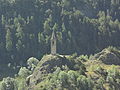
Méolans church tower


Web links
Commons : Méolans-Revel - collection of images, videos and audio files