
Prunières (Hautes-Alpes)
| Prunières | ||
|---|---|---|

|
|
|
| region | Provence-Alpes-Cote d'Azur | |
| Department | Hautes-Alpes | |
| Arrondissement | Gap | |
| Canton | Chorges | |
| Community association | Serre poncon | |
| Coordinates | 44 ° 33 ' N , 6 ° 20' E | |
| height | 770-2,390 m | |
| surface | 13.2 km 2 | |
| Residents | 298 (January 1, 2017) | |
| Population density | 23 inhabitants / km 2 | |
| Post Code | 05230 | |
| INSEE code | 05106 | |
 Prunières |
||

Prunières is a French commune in the Hautes-Alpes in the region of Provence-Alpes-Cote d'Azur . It belongs to the canton of Chorges in the Gap arrondissement .
geography
Prunières is located on the north bank of the Lac de Serre-Ponçon , opposite Pontis . The other neighboring communities are Réallon in the north, Saint-Apollinaire and Savines-le-Lac in the east and Chorges in the west. The Mairie is located in the Les Clots district . In addition, the hamlets of Pra Périer, Verièr (site of the castle), Les Vignes, Le Lauguet and Champioga on Route nationale 94 belong to Prunières.
Population development
| year | 1962 | 1968 | 1975 | 1982 | 1990 | 1999 | 2008 | 2012 |
|---|---|---|---|---|---|---|---|---|
| Residents | 154 | 154 | 121 | 138 | 175 | 232 | 289 | 294 |

Saint-Michel chapel on the Lac de Serre-Ponçon reservoir at low tide
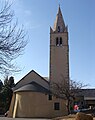
Saint-Sauveur church

lock


Web links
Commons : Prunières - Collection of images, videos and audio files