Larche (Alpes-de-Haute-Provence)
| Larch | ||
|---|---|---|
|
|
||
| local community | Val d'Oronaye | |
| region | Provence-Alpes-Cote d'Azur | |
| Department | Alpes-de-Haute-Provence | |
| Arrondissement | Barcelonnette | |
| Coordinates | 44 ° 27 ' N , 6 ° 51' E | |
| Post Code | 04530 | |
| Former INSEE code | 04100 | |
| Incorporation | January 1, 2016 | |
| status | Commune déléguée | |
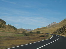
 Larche with the Monte Sautron |
||
Larche is a former French municipality with 58 inhabitants (at January 1, 2017) in the department of Alpes-de-Haute-Provence in the region Provence-Alpes-Cote d'Azur .
With effect from January 1, 2016, it merged with the former municipality of Meyronnes and thus formed the Commune nouvelle Val d'Oronaye .
geography
The area is in the French Maritime Alps . It borders on Argentera and Acceglio in Italy to the east . The village center is at 1697 m above the Ubaye valley .
Surveys
- Monte Sautron, 3165 m
- Col de Larche , in Italian Colle della Maddalena , 1995 m
- Tete du Coin de l'Ours, 2728 m
- Tete de Viraysse, 2768 m
- Bec de l'Aigle, 2815 m
- Tete de Fer, 2883 m
- Tete de l'Enchastraye, 2954 m
- La Meyna, 3067 m
- Tete de Moïse, 3104 m
- Rocca Blanca, 3193 m
Population development
| year | 1962 | 1968 | 1975 | 1982 | 1990 | 1999 | 2008 | 2012 |
|---|---|---|---|---|---|---|---|---|
| Residents | 102 | 128 | 100 | 91 | 71 | 83 | 72 | 62 |
Web links
Commons : Larche - collection of images, videos and audio files

