
Col de Braus
| Col de Braus | |||
|---|---|---|---|
 The tomb of René Vietto on the top of the Col de Braus |
|||
| Compass direction | west | east | |
| Pass height | 1002 m | ||
| region | Alpes-Maritimes , Provence-Alpes-Cote d'Azur , France | ||
| Valley locations | L'Escarène | Sospel | |
| expansion | D 2204 / railway tunnel | ||
| Mountains | Maritime Alps | ||
| map | |||
|
|||
| Coordinates | 43 ° 52 '18 " N , 7 ° 23' 48" E | ||

The Col de Braus is a mountain pass in the French Maritime Alps in the Alpes-Maritimes department of the Provence-Alpes-Côte d'Azur region . He connects Sospel with L'Escarène ; the pass is at 1002 m above sea level . The pass is crossed by the 5938-meter-long Tunnel du Col Braus of the Tendabahn . The Col de Braus was an important passage point on the former salt route from Nice to Turin.
At the top of the pass is the tomb of René Vietto , a popular cyclist in the 1930s and 1940s and multiple wearer of the Tour de France yellow jersey .
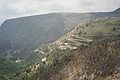
Serpentine sequence towards L'Escaréne

Serpentine sequence towards Sospel

Gun emplacement at Sospel near the Franco-Italian border


Web links
Agnel • Allos • Andrion • Aravis • Bonette • Braus • Cayolle • Champs • Colle-Saint-Michel • Colombière • Croix de Fer • Croix-Fry • Cuillole • Galibier • Gets • Glandon • Granon • Iseran • Izoard • Jambaz • Joux Plane • Joux Verte • Larche • Lautaret • Lebraut • Lombarde • Madeleine • Saint Martin • Méraillet • Mollard • Mont Cenis • Montets • Montgenèvre • Morgins • Moutière • Ornon • Pré • Petit Saint-Bernard • Pontis • Ramaz • Roselend • Rousset • Saisies • Télégraphe • Tende • Turini • Valberg • Vars