
Col du Glandon
| Col du Glandon | |||
|---|---|---|---|
 View of the top of the pass |
|||
| Compass direction | North side | Southwest side | |
| Pass height | 1924 m | ||
| Department | Savoie , France | ||
| Valley locations | Sainte-Etienne-de-Cuines | Rochetaillée | |
| expansion | Pass road | ||
| Built | 1898/1912 | ||
| Winter closure | October - May | ||
| Mountains | french alps | ||
| profile | |||
| Ø pitch | 6.9% (1476 m / 21.3 km) | 4.2% (1206 m / 29 km) | |
| Max. Incline | (at km 11.5) | (at km 11.4) | |
| map | |||
|
|||
| Coordinates | 45 ° 14 '24 " N , 6 ° 10' 30" E | ||

The Col du Glandon is a French alpine pass. The 1924 meter high crossing is in the Auvergne-Rhône-Alpes region ( Savoie department ). It connects Rochetaillée near Le Bourg-d'Oisans in the Romanche valley with La Chambre in the Maurienne valley . Opened in 1898, in 1912 it was connected to the slightly higher and only 2.5 km away Col de la Croix de Fer , which leads to Saint-Jean-de-Maurienne . The Col du Glandon is navigable between May and October. The climb from La Chambre is marked with special signs for cyclists every kilometer .
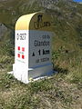
The last special milestone for cyclists before the pass on the climb from La Chambre

literature
- Kristian Bauer: Roadbook Tour de France. Conquer 40 top climbs from the Alps to the Pyrenees on your own racing bike. (Plus highlights from the history of the tour). Bruckmann, Munich 2006, ISBN 3-7654-4477-4 .
Web links
Agnel • Allos • Andrion • Aravis • Bonette • Braus • Cayolle • Champs • Colle-Saint-Michel • Colombière • Croix de Fer • Croix-Fry • Cuillole • Galibier • Gets • Glandon • Granon • Iseran • Izoard • Jambaz • Joux Plane • Joux Verte • Larche • Lautaret • Lebraut • Lombarde • Madeleine • Saint Martin • Méraillet • Mollard • Mont Cenis • Montets • Montgenèvre • Morgins • Moutière • Ornon • Pré • Petit Saint-Bernard • Pontis • Ramaz • Roselend • Rousset • Saisies • Télégraphe • Tende • Turini • Valberg • Vars