Romanche
| Romanche | ||
|
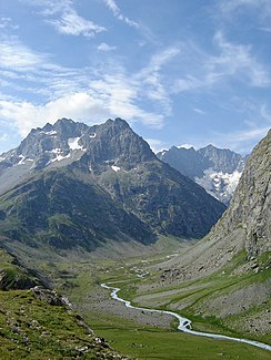
Upper reaches of the Romanche |
||
| Data | ||
| Water code | FR : W27-0400 | |
| location | France , regions Provence-Alpes-Cote d'Azur and Auvergne-Rhône-Alpes | |
| River system | Rhône | |
| Drain over | Drac → Isère → Rhône → Mediterranean | |
| source | in the municipal area of Villar-d'Arêne 44 ° 58 ′ 2 ″ N , 6 ° 21 ′ 54 ″ E |
|
| Source height | approx. 2300 m | |
| muzzle | on the municipal boundary of Champ-sur-Drac and Jarrie in the Drac coordinates: 45 ° 5 '25 " N , 5 ° 43' 32" E 45 ° 5 '25 " N , 5 ° 43' 32" E |
|
| Mouth height | approx. 260 m | |
| Height difference | approx. 2040 m | |
| Bottom slope | approx. 26 ‰ | |
| length | 78 km | |
| Left tributaries | Vénéon | |
| Right tributaries | Eau d'Olle | |
| Reservoirs flowed through | Lac du Chambon | |
| Small towns | Vizille | |
The Romanche is a mountain river in France that runs through the Provence-Alpes-Côte d'Azur and Auvergne-Rhône-Alpes regions. It rises in the northern part of the central Dauphiné Alps , in the Écrins National Park , below the Plate des Agnaux glacier , in the municipal area of Villar-d'Arêne , generally drains west to northwest through the Vallée de la Romanche, which is named after it, and flows out at 78 Kilometers south of Grenoble , on the municipal boundary of Champ-sur-Drac and Jarrie , as a right tributary to the Drac . On its way, the Romanche crosses the Hautes-Alpes and Isère departments .
Places on the river
- Villar-d'Arêne
- La Grave
- Le Freney-d'Oisans
- Le Bourg-d'Oisans
- Livet-et-Gavet
- Séchilienne
- Vizille
- Champ-sur-Drac
Attractions
At Freney-d'Oisans the Romanche is dammed up to the Lac du Chambon . Below the village, the river forms the imposing Gorges de l'Infernet gorge . The white waters of the upper Romanche are suitable for kayaking and rafting.
Web links
Individual evidence
- ↑ Source geoportail.gouv.fr
- ↑ estuary geoportail.gouv.fr
- ↑ a b The information on the length of the river is based on the information on the Romanche from SANDRE (French), accessed on December 2, 2012, rounded to full kilometers.
