Jarrie
| Jarrie | ||
|---|---|---|

|
|
|
| region | Auvergne-Rhône-Alpes | |
| Department | Isère | |
| Arrondissement | Grenoble | |
| Canton | Le Pont-de-Claix | |
| Community association | Grenoble-Alpes metropolis | |
| Coordinates | 45 ° 7 ' N , 5 ° 46' E | |
| height | 259-733 m | |
| surface | 13.26 km 2 | |
| Residents | 3,746 (January 1, 2017) | |
| Population density | 283 inhabitants / km 2 | |
| Post Code | 38560 | |
| INSEE code | 38200 | |
| Website | www.ville-jarrie.fr | |
 Jarrie in the Chartreuse Mountains from the air |
||
Jarrie is a French municipality with 3746 inhabitants (as of January 1 2017) in the department of Isère in the region Auvergne Rhône-Alpes . It belongs to the Grenoble Alpes Métropole municipal association , the Arrondissement Grenoble and is part of the canton of Le Pont-de-Claix . The inhabitants are called Jarriards or Jarrois .
geography
Jarrie is about twelve kilometers south-southeast of Grenoble . In the south, the Romanche , which flows into the Drac there, limits the community. Jarrie is surrounded by the neighboring communities of Bresson in the north, Brié-et-Angonnes in the east and northeast, Montchaboud in the southeast, Champ-sur-Drac in the south, Champagnier in the west and Échirolles in the northwest.
Route nationale 85 runs along the southern edge of the municipality .
Population development
| 1962 | 1968 | 1975 | 1982 | 1990 | 1999 | 2006 | 2011 |
| 2.167 | 2,084 | 2,009 | 2,807 | 3,809 | 4,009 | 3,864 | 3,845 |
Attractions
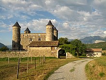
- Bon Repos Castle, Monument historique since 1986
- Haute-Jarrie Lake Natural Park
Parish partnership
There is a partnership with the Spanish municipality of Macael in the province of Almería (Andalusia) .
economy
The chemical company Arkema has a production site in Jarrie.


