Saint-Martin-d'Uriage
| Saint-Martin-d'Uriage | ||
|---|---|---|

|
|
|
| region | Auvergne-Rhône-Alpes | |
| Department | Isère | |
| Arrondissement | Grenoble | |
| Canton | Oisans Romanche | |
| Community association | Le Grésivaudan | |
| Coordinates | 45 ° 9 ′ N , 5 ° 50 ′ E | |
| height | 320-2,200 m | |
| surface | 29.69 km 2 | |
| Residents | 5,451 (January 1, 2017) | |
| Population density | 184 inhabitants / km 2 | |
| Post Code | 38410 | |
| INSEE code | 38422 | |
| Website | www.saint-martin-uriage.com/ | |
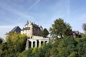
 Château d'Uriage |
||
Saint-Martin-d'Uriage is a French municipality with 5451 inhabitants (as of January 1 2017) in the department of Isère in the region Auvergne Rhône-Alpes . It belongs to the Arrondissement of Grenoble and is part of the canton of Oisans-Romanche . The inhabitants are called Saint-Martinois .
geography
Saint-Martin-d'Uriage is located between Grenoble and the Belledonne mountain range . Saint-Martin-d'Uriage is surrounded by the neighboring communities of Revel in the north and east, Chamrousse in the south-east, Vaulnaveys-le-Haut in the south, Herbeys in the west and Gières , Venon and Murianette in the north-west.
In addition to the main town of Saint-Martin , the municipality consists of the localities of Saint-Nizier , Le Pinet d'Uriage , Villeneuve d'Uriage and Uriage-les-Bains as well as several smaller hamlets and lieux-dits .
history
During the Huguenot Wars fights took place in the region, of which the Battle of Jarrie (also called Battle of Uriage) took place on August 19, 1587 in the immediate vicinity of the place. Despite being significantly outnumbered, the Catholic troops won over the united Protestant troops and Swiss mercenaries as a result of greater experience, stronger cavalry and better starting position and tactics.
The thermal springs on the territory of the municipality were already being used during the Roman Empire . In the 19th century, a thermal bath was established in Uriage-les-Bains, which closed again as a result of the economic crisis of the 1930s and the Second World War, and was renovated and reopened in the 1980s.
During the Second World War, the État français established an elite school in the Château d'Uriage in 1940 , but it was closed again at the end of 1942 due to increasing criticism from teachers and students of the government's policy of collaboration. Instead, the collaborationist Milice française took over the school for training their cadres in early 1943 .
A regional tram line of the Voies ferrées du Dauphiné between Grenoble and Vizille served the district of Uriage-les-Bains from 1894 to 1951.
Population development
| 1962 | 1968 | 1975 | 1982 | 1990 | 1999 | 2006 | 2011 | |
|---|---|---|---|---|---|---|---|---|
| 1,354 | 1,511 | 1,815 | 2,527 | 3,678 | 4,794 | 5,147 | 5,460 | |
| Sources: Cassini and INSEE | ||||||||
Personalities
- Baptiste Alexis Victor Legrand (1791–1848), engineer and politician
Attractions
- Saint Ferréol Church by Pinet d'Uriage
- Chapel in Saint-Nizier
- Château d'Uriage
- Baths of Uriage
- park
- Wash house
- Casino and Grand Hotel
Web links
- Official website of the municipality (French)
- Tourism Association website (French)
proof
- ↑ Guy Le Comte: La triste histoire d'un régiment perdu, en un temps troublé: la bataille de Jarrie (1587) . In: Bulletin de la SHAG . No. 40, 2010, pp. 28-39.
- ↑ L'histore des thermes ( fr ) Établissement thermal Uriage. 2017.
- ↑ Denis Boneau: Uriage, l'école des cadres de la Collaboration ( fr ) Réseau Voltaire. April 23, 2004.
- ^ Jean Martin: Ligne VFD Grenoble - Oisans via Uriage et Vizille ( fr ) January 2, 2016.
