Saint-Christophe-en-Oisans
| Saint-Christophe-en-Oisans | ||
|---|---|---|
|
|
||
| region | Auvergne-Rhône-Alpes | |
| Department | Isère | |
| Arrondissement | Grenoble | |
| Canton | Oisans Romanche | |
| Community association | Oisans | |
| Coordinates | 44 ° 57 ′ N , 6 ° 11 ′ E | |
| height | 1,168-4,008 m | |
| surface | 123.47 km 2 | |
| Residents | 107 (January 1, 2017) | |
| Population density | 1 inhabitant / km 2 | |
| Post Code | 38520 | |
| INSEE code | 38375 | |
Saint-Christophe-en-Oisans is a commune in the French Alps in the department of Isère in the region Auvergne Rhône-Alpes . The municipal area amounts to 12,347 hectares at altitudes between 1,168 and 4,008 meters on the Dôme de Neige des Écrins, a secondary peak of the Barre des Écrins . The community has 107 inhabitants (as of January 1, 2017), the population density is about one person per square kilometer. Saint-Christophe-en-Oisans is the easternmost commune of the Isère department.
Saint-Christophe
Saint-Christophe-en-Oisans is also the name of the small main settlement in the municipality on the upper Vénéon , which can be reached by car from Grenoble via 91 Rue Nationale. Follow the national road towards Briançon until about 4 kilometers past Le Bourg-d'Oisans and then turn right into the Vénéon valley.
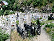
The Austrian mountaineer Emil Zsigmondy , who fell to death on the south face of the 3,983-meter-high Meije above La Bérarde while attempting to ascent for the first time, was laid to rest in the cemetery of Saint-Christophe . There is also an Alpine Museum on site, which is particularly dedicated to the history of the region and the development of the Écrins massif . The Plan du Lac car park on the access road below the village is the starting point for an interesting and partially exposed via ferrata that leads up the walls towards the terrace of Saint-Christophe.
La Bérarde
More widely known than Saint-Christophe is the small hamlet of La Bérarde ( 1740 m ) , which also belongs to the municipality . La Bérarde can only be reached in the summer season via a narrow mountain road from Saint-Christophe. On the way there you pass the few houses of les Etages . The street now has a sufficient number of alternative bays (French garages ). In the past, it was only allowed to drive up or downhill in one direction at certain times. From Grenoble there is a bus connection in July and August via le Bourg-d'Oisans and St. Christophe to La Bérarde.
Located at the foot of the highest mountains in the Oisans ( Meije , Barre des Écrins and Ailefroide ) at the confluence of the Vénéon and Etançons stream, La Bérarde in the heart of the Écrins massif is a Mecca for mountaineers , hikers and nature lovers. It has a campsite, an Alpine Center "Center Alpin Français" of the French Alpine Club CAF (open from mid-June to mid-September, overnight accommodation) and restaurants.
The viewing summit of the Tête de la Maye , 2517 m , which can be reached in around two hours via a partly narrow path , offers a rewarding view of several high peaks of the central Dauphiné Alps , above all the Meije with its vertical south-facing slopes and the high valleys of Etançon, Bonne Pierre and Vénéon.
geography
The municipality of Saint-Christophe occupies the largely natural high valley of the Vénéon in the center of the Écrins-Massifs, which is better known in the German-speaking area under the names Dauphiné Alps or (not entirely clean) simply Dauphiné . About a fifth of the Écrins National Park , which is home to the southernmost four-thousand-meter peak in the Alps , the Barre des Écrins , is in the municipality.
Web links
- La Bérarde and Saint-Christophe (French)
- Alpine Museum in Saint-Christophe (French)
- Homepage of the communes des Oisans (French / English)


