Vinay (Isere)
| Vinay | ||
|---|---|---|

|
|
|
| region | Auvergne-Rhône-Alpes | |
| Department | Isère | |
| Arrondissement | Grenoble | |
| Canton | Le Sud Grésivaudan | |
| Community association | Saint-Marcellin Vercors Isère Communauté | |
| Coordinates | 45 ° 13 ' N , 5 ° 24' E | |
| height | 168-580 m | |
| surface | 16.01 km 2 | |
| Residents | 4,251 (January 1, 2017) | |
| Population density | 266 inhabitants / km 2 | |
| Post Code | 38470 | |
| INSEE code | 38559 | |
| Website | vinay.fr | |
Vinay is a commune with 4251 inhabitants (at January 1, 2017) in the department of Isère in the region Auvergne Rhône-Alpes ; it belongs to the Arrondissement of Grenoble and the canton of Le Sud Grésivaudan .
geography
Vinay is located on the lower reaches of the Isère in Bas Grésivaudan , halfway between Grenoble and Valence , at the foot of the Vercors massif and below the Montvinay mountain and its castle. The city is located to the northwest of the Vercors Regional Nature Park , with which it is associated as an access point.
Vinay is the center of the largest nut growing area in Europe ( AOC Noix de Grenoble).
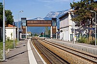
The municipality has a train station on the Valence – Moirans railway line , which is served by TER-Rhône-Alpes trains. The line was electrified between 2011 and 2013. To do this, it had to be partially closed during the summer months. The nearest TGV stations are Valence TGV and Grenoble train station .
Vinay has a junction on the A 49 autoroute which runs south of the community center. In addition, the D1092 (former national road) runs through the town.
Population development
- 1962: 2721
- 1968: 2925
- 1975: 3198
- 1982: 3376
- 1990: 3410
- 1999: 3525
- 2017: 4251
Attractions
- Montvinay Castle
- The Grand Séchoir , a museum dedicated to the Noix de Grenoble
Web links
- vinay.fr (Official Website)

