
Vercors Regional Natural Park


The Regional Nature Park Vercors ( fr. Parc naturel régional du Vercors ) is located in the same country Vercors in the French region of Auvergne Rhône-Alpes . It comprises parts of the Isère and Drôme departments and is only separated from the neighboring Chartreuse Regional Nature Park in the northeast by the Isère valley .
Park management
The nature park was founded on October 16, 1970 and today covers an area of around 206,000 hectares. The park administration is based in Lans-en-Vercors ( 45 ° 7 ′ 47 " N , 5 ° 35 ′ 17" E, ), where the " Maison du Parc ”is located. 85 communities with a catchment area of around 53,000 residents make up the park. In addition, the municipalities of Crest , Grenoble , Romans-sur-Isère , Saint-Marcellin and Vinay are associated with the park as access points.
Larger places in the park
Located on the edge of the nature park (only parts of the area belong to the park):
Entirely located in the nature park (entire area belongs to the park):
Landscapes
The Vercors is a self-contained mountain massif with a long, hilly high valley oriented from north to south. Due to its structure, the area can be divided into the following landscapes:
- Quatre Montagnes
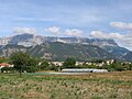
The Quatre Montagnes (German: Four Mountains) landscape is just west of Grenoble and is the most developed area for tourism in the Vercors. It is very much appreciated by the residents of Grenoble for their weekend trips and is also ideally suited for winter sports (cross-country skiing, alpine skiing). Nevertheless, there are still traditional crafts in the Quatre Montagnes, especially cattle breeding and cheese production . The mountain range rises from the north (Moucherotte, 1901 m) to the south (Grande Moucherolle, 2284 m) and drops steeply to the east towards the Drac valley . The Drac flows into the Isère , which delimits the area to the north and north-west. The Bourne River rises in the center of the landscape and runs southwest and west. In the Grenoble agglomeration, some densely populated municipalities with territorial shares extend into the nature park (e.g. Fontaine , Sassenage , Seyssinet-Pariset ).

Dog sledding in Méaudre
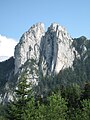
"Les Trois Pucelles" rock formation near Saint-Nizier-du-Moucherotte
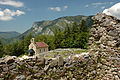
Calvary Chapel Valchevrière to the west of Villard-de-Lans

Gorge of the Bourne River to the west of Villard-de-Lans

Villard-de-Lanse view of the mountain range to the east


.JPG)
- Hauts-Plateaux du Vercors
The Hauts-Plateaux du Vercors landscape is the highest area in the nature park (Grand Veymont, 2341 m). While to the east the elongated mountain ridge plunges steeply down to the Trièves landscape , to the west the height decreases and merges into karst plateaus. This landscape represents a special nature protection zone, there are neither permanent residents nor paved roads, all motorized traffic is prohibited. There are few exceptions for forest and alpine farming in the summer months.

The eastern ridge of the Vercors Mountains

Grand Veymont (2341 m)
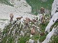
Ibex at Grand Veymont

Grand Veymont and Mont Aiguille

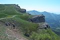
Karst phenomena on the Plateau du Roi


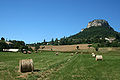
- Vercors drômois
The Vercors drômois (Eng .: Vercors in the Drôme department) is located in the center of the nature park and consists of many small plateaus. Some of these plains are spectacular ( Plateau d'Ambel , Plateau Font d'Urle ) and offer a wonderful view of each other or the surrounding plains. In the north of the landscape there are impressive gorges, where the roads had to be painstakingly carved into the rock. The grassy plains of the Vercors drômois are used as pastureland in summer.
Plateau d'Ambel

Near the Font d'Urle

View from Col de la Bataille

At the Col de Tourniol

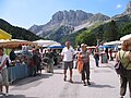
Vassieux-en-Vercors


At the edge of the nature park there are still shares in the following landscapes:
- Coulmes
The Coulmes landscape lies in the northwest of the nature park and has always been the most wooded part of the Vercors. In the 19th century, the forest was used especially for the production of charcoal . In this area, the Vercors has a rather hilly shape, as the Uronian limestone plates have already been rounded off. You come across impressive roads through narrow gorges, such as B. the Gorge du Nan and the Canyon des Ecouges .

Cognin-les-Gorges with the entrance to the Vercors

Cognin-les-Gorges

Waterfall at the Gorge du Nan

The Gorge du Nan


- Royans
The Royans landscape lies in the west of the nature park and is a hilly area, in which one devotes himself particularly to the breeding and cultivation of nut trees . Three of the most impressive gorges of the Vercors run here: the gorges of the river Bourne , the valley of the Vernaisson with the narrow openings of the Petit and Grand Goulet and the valley head Cirque de Laval .
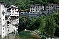
Pont-en-Royans on the Bourne River

The Bourne at Pont-en-Royans

Anticline near Pont-en-Royans

Saint-Laurent-en-Royans

Orthodox monastery in the Combe Laval valley head


.jpg)
- Gervanne
The Gervanne landscape, in the southwest of the nature park, lies in the catchment area of the Gervanne river of the same name . It is an area of rugged hills at the foot of the plateau, where there are many pretty villages. It is mainly oriented towards the Crest , which is already outside the nature park.
Plan-de-Baix in the Gervanne
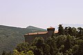
Montrond Castle in Plan-de-Baix

Beaufort-sur-Gervanne

Gigors-et-Lozeron
Monclar-sur-Gervanne just outside the nature park


- Diois
The Diois landscape lies in the south of the nature park and comprises part of the Drôme valley around the town of Die . This area already has a stronger Mediterranean character, with vineyards and lavender fields . This is a transition zone between the Gervanne and the interior of the Vercors massif.

The Drôme at Die
The Glandasse Mountains in the Vercors

Châtillon-en-Diois

Gorge des Gats at Glandage

Lus-la-Croix-Haute


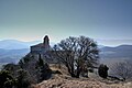
- Trièves
The Trièves landscape, to the east of the nature park, is a low hill plateau between the highest peaks of the Vercors and the Drac gorges. It is drained by the river Ébron and is completely isolated from the other areas in the nature park by the continuous mountain range or can only be reached by extensive bypasses.

The Trèves valley seen from the Vercors plateau

Mont Aiguille and Grand Veymont as seen from Trièves

Darne Viaduct at Clelles

Mont Aiguille seen from Ruthière, Chichilianne parish
Almabtriebsfest in Gresse

_2.jpg)


Flora and fauna
In the south and west, Mediterranean plains and hilly mountainous areas predominate, while in the north and east, mountain forests and high valleys are dominated by a harsher alpine climate. The milder areas are used for agriculture. Deciduous forests with oaks and beeches , including pines , populate the more natural areas. In the higher elevations, coniferous forests predominate, mainly with pines and spruces , flat plateaus are used as pasture or are heather . Around 1800 plant species , including 60 orchids, thrive in the nature park . 135 species of birds and 65 species of mammals have found what was, in some cases, the last reserve here.
For more details, see flora and fauna .
See also
Web links
- Website of the nature park (French)