Seyssins
| Seyssins | ||
|---|---|---|

|
|
|
| region | Auvergne-Rhône-Alpes | |
| Department | Isère | |
| Arrondissement | Grenoble | |
| Canton | Fontaine-Seyssinet | |
| Community association | Grenoble-Alpes metropolis | |
| Coordinates | 45 ° 10 ′ N , 5 ° 41 ′ E | |
| height | 219-1,897 m | |
| surface | 8 km 2 | |
| Residents | 7,685 (January 1, 2017) | |
| Population density | 961 inhabitants / km 2 | |
| Post Code | 38180 | |
| INSEE code | 38486 | |
| Website | www.mairie-seyssins.fr | |
 "Le Prisme" event room |
||
Seyssins is a French municipality with 7685 inhabitants (as of January 1 2017) in the department of Isère in the region Auvergne Rhône-Alpes . The municipality belongs to the canton of Fontaine-Seyssinet in the Arrondissement of Grenoble . The inhabitants are called Seyssinoises .
geography
Seyssins is located on the edge of the Vercors Mountains southwest of Grenoble , on the western bank of the Drac River . It is surrounded by the neighboring communities Seyssinet-Pariset in the north, Grenoble in the northeast, Échirolles in the east, Claix in the south and Saint-Nizier-du-Moucherotte in the west. Parts of the municipality belong to the Vercors Regional Nature Park .
history
In 1790 and 1794 the parish was expanded. The places Mont-Rigaud and Roux-de-Commiers were added.
Population development
| year | 1936 | 1946 | 1954 | 1962 | 1968 | 1975 | 1982 | 1990 | 1999 | 2006 | 2011 |
|---|---|---|---|---|---|---|---|---|---|---|---|
| Residents | 513 | 500 | 762 | 1.007 | 1,573 | 3,911 | 5,021 | 7,028 | 6,850 | 6,861 | 6,887 |
Attractions
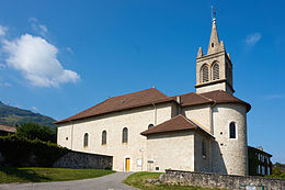
- Saint-Martin church from the 9th century with alterations in the 12th century
- Memorial to the dead of the First World War, erected in 1920
Personalities
- Didier Migaud (* 1952), politician, former mayor of Seyssins and former president of the Cour des Comptes

