Engins
| Engins | ||
|---|---|---|
|
|
||
| region | Auvergne-Rhône-Alpes | |
| Department | Isère | |
| Arrondissement | Grenoble | |
| Canton | Fontaine-Vercors | |
| Community association | Massif du Vercors | |
| Coordinates | 45 ° 11 ' N , 5 ° 37' E | |
| height | 560–2,064 m | |
| surface | 20.64 km 2 | |
| Residents | 465 (January 1, 2017) | |
| Population density | 23 inhabitants / km 2 | |
| Post Code | 38360 | |
| INSEE code | 38153 | |
| Website | http://www.engins.fr/ | |
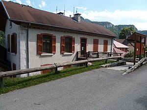
 Town hall (Mairie) of Engins |
||
Engins is a French municipality with 465 inhabitants (as of January 1 2017) in the department of Isère in the region Auvergne Rhône-Alpes . The municipality belongs to the Arrondissement of Grenoble and the canton of Fontaine-Vercors . The inhabitants are called Enginois .
geography
Engins is located about nine kilometers west-southwest of Grenoble on the Furon River on a plateau in the Vercors Mountains. The municipality is located in the Vercors Regional Nature Park . Engins is surrounded by the neighboring municipalities of Noyarey in the north, Sassenage in the northeast, Fontaine in the east, Saint-Nizier-du-Moucherotte in the southeast, Lans-en-Vercors in the south and Autrans-Méaudre en Vercors in the west and southwest.
Population development
| 1962 | 1968 | 1975 | 1982 | 1990 | 1999 | 2006 | 2013 | |
|---|---|---|---|---|---|---|---|---|
| 192 | 151 | 151 | 288 | 352 | 420 | 465 | 496 | |
| Sources: Cassini and INSEE | ||||||||
Attractions
- Church, built at the end of the 11th / beginning of the 12th century
- Dam wall
Web links
Commons : Engins - collection of images, videos and audio files

