
Saint-Nicolas-de-Macherin
| Saint-Nicolas-de-Macherin | ||
|---|---|---|
|
||
| region | Auvergne-Rhône-Alpes | |
| Department | Isère | |
| Arrondissement | Grenoble | |
| Canton | Voiron | |
| Community association | Pays Voironnais | |
| Coordinates | 45 ° 24 ' N , 5 ° 36' E | |
| height | 447-952 m | |
| surface | 10.6 km 2 | |
| Residents | 938 (January 1, 2017) | |
| Population density | 88 inhabitants / km 2 | |
| Post Code | 38500 | |
| INSEE code | 38432 | |
| Website | http://www.mairie-saintnicolasdemacherin.fr/ | |

Saint-Nicolas-de-maker is a French municipality with 938 inhabitants (as of January 1 2017) in the department of Isère in the region Auvergne Rhône-Alpes . The municipality is located in the Arrondissement of Grenoble and belongs to the canton of Voiron .
geography
Saint-Nicolas-de-Macherin is located about 24 kilometers north-north-west of Grenoble . Saint-Nicolas-de-Macherin is surrounded by the neighboring communities of Massieu in the north, Merlas in the northeast, Saint-Aupre in the east, Saint-Étienne-de-Crossey in the south and southeast, Voiron in the west and southwest and Chirens in the northwest.
Population development
| 1962 | 1968 | 1975 | 1982 | 1990 | 1999 | 2006 | 2013 | |
|---|---|---|---|---|---|---|---|---|
| 384 | 380 | 389 | 518 | 615 | 782 | 863 | 873 | |
| Sources: Cassini and INSEE | ||||||||
Attractions
- Saint-Nicolas church from the 19th century
- Hautefort Castle with a chapel from the 15th century, rebuilt in the 17th century
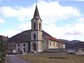
Saint-Nicolas church

Hautefort Castle


Web links
Commons : Saint-Nicolas-de-Macherin - Collection of images, videos and audio files