
Vatilieu
| Vatilieu | ||
|---|---|---|
|
||
| region | Auvergne-Rhône-Alpes | |
| Department | Isère | |
| Arrondissement | Grenoble | |
| Canton | Le Sud Grésivaudan | |
| Community association | Saint-Marcellin Vercors Isère Communauté | |
| Coordinates | 45 ° 15 ′ N , 5 ° 25 ′ E | |
| height | 352-787 m | |
| surface | 9.22 km 2 | |
| Residents | 365 (January 1, 2017) | |
| Population density | 40 inhabitants / km 2 | |
| Post Code | 38470 | |
| INSEE code | 38526 | |
| Website | http://vatilieu.sud-gresivaudan.org/ | |
 Vatilieu Town Hall |
||

Vatilieu is a French commune of 365 inhabitants (as of January 1 2017) in the department of Isère in the region Auvergne Rhône-Alpes . The municipality is located in the Arrondissement of Grenoble and belongs to the canton of Le Sud Grésivaudan (until 2015: canton of Tullins ).
geography
Vatilieu is about 25 kilometers west-northwest of Grenoble . Vatilieu is surrounded by the neighboring communities of La Forteresse in the north, Cras in the east and northeast, Chantesse in the east and southeast, Notre-Dame-de-l'Osier in the south, Serre-Nerpol in the west and Quincieu in the northwest.
Population development
| 1962 | 1968 | 1975 | 1982 | 1990 | 1999 | 2006 | 2017 | |
|---|---|---|---|---|---|---|---|---|
| 203 | 203 | 165 | 265 | 315 | 339 | 369 | 365 | |
| Sources: Cassini and INSEE | ||||||||
Attractions
- 19th century Saint Martin church
- Remains of the old castle complex
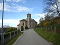
Saint Martin Church

Remains of the old castle complex with ruined tower


Web links
Commons : Vatilieu - collection of images, videos and audio files