Le Sappey-en-Chartreuse
| Le Sappey-en-Chartreuse | ||
|---|---|---|
|
|
||
| region | Auvergne-Rhône-Alpes | |
| Department | Isère | |
| Arrondissement | Grenoble | |
| Canton | Meylan | |
| Community association | Grenoble-Alpes metropolis | |
| Coordinates | 45 ° 16 ' N , 5 ° 47' E | |
| height | 840–2,079 m | |
| surface | 15.13 km 2 | |
| Residents | 1,121 (January 1, 2017) | |
| Population density | 74 inhabitants / km 2 | |
| Post Code | 38700 | |
| INSEE code | 38471 | |
| Website | http://www.sappey-mairie.fr | |
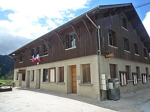
 Town hall of Le Sappey-en-Chartreuse |
||
Le Sappey-en-Chartreuse is a French commune with 1,121 inhabitants (as of January 1 2017) in the department of Isère in the region Auvergne Rhône-Alpes . It belongs to the Arrondissement of Grenoble and the Canton of Meylan . The inhabitants call themselves Sappeyards .
geography
Le Sappey-en-Chartreuse is located on the edge of the metropolitan area northeast of Grenoble in the Chartreuse massif . Le Sappey-en-Chartreuse is surrounded by the neighboring communities of Saint-Pierre-de-Chartreuse in the north, Saint-Ismier in the east, Biviers in the south-east, Meylan in the south and south-east, Corenc in the south, Quaix-en-Chartreuse in the west and south-west as well as Sarcenas to the west and northwest.
Population development
| year | 1962 | 1968 | 1975 | 1982 | 1990 | 1999 | 2006 | 2012 |
| Residents | 234 | 285 | 371 | 557 | 762 | 942 | 1.007 | 1.101 |
Attractions
- Church from 1115, rebuilt and expanded in the 17th and 19th centuries, bell tower from 1665 ( Monument historique )
- Fort Saint-Eynard, built between 1873 and 1879
Web links
Commons : Le Sappey-en-Chartreuse - collection of images, videos and audio files

