
Vourey
| Vourey | ||
|---|---|---|

|
|
|
| region | Auvergne-Rhône-Alpes | |
| Department | Isère | |
| Arrondissement | Grenoble | |
| Canton | Tullins | |
| Community association | Pays Voironnais | |
| Coordinates | 45 ° 19 ′ N , 5 ° 31 ′ E | |
| height | 181-402 m | |
| surface | 6.88 km 2 | |
| Residents | 1,705 (January 1, 2017) | |
| Population density | 248 inhabitants / km 2 | |
| Post Code | 38210 | |
| INSEE code | 38566 | |
| Website | http://www.commune-vourey.fr/ | |

Vourey is a French commune with 1,705 inhabitants (as of January 1 2017) in the department of Isère in the region Auvergne Rhône-Alpes . The municipality is located in the arrondissement of Grenoble and belongs to the canton of Tullins (until 2015: canton of Rives ).
geography
Vourey is about 25 kilometers northwest of Grenoble . Vourey is surrounded by the neighboring communities of Charnècles in the north, Moirans in the east, Saint-Quentin-sur-Isère in the south and south-east, Tullins in the west and south-west and Renage in the north-west.
Population development
| 1962 | 1968 | 1975 | 1982 | 1990 | 1999 | 2006 | 2017 | |
|---|---|---|---|---|---|---|---|---|
| 677 | 672 | 761 | 1033 | 1236 | 1548 | 1640 | 1705 | |
| Sources: Cassini and INSEE | ||||||||
Attractions
- Saint Martin Church
- Sanissard Chapel
- Val-Marie Castle
- La Bâtie Castle
- Mill
- town hall
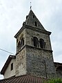
Bell tower of the Saint-Martin church

Val-Marie Castle


Personalities
- Joseph Paganon (1880–1937), politician and minister (1933–1936)
Web links
Commons : Vourey - collection of images, videos and audio files