Le Pont-de-Claix
| Le Pont-de-Claix | ||
|---|---|---|

|
|
|
| region | Auvergne-Rhône-Alpes | |
| Department | Isère | |
| Arrondissement | Grenoble | |
| Canton | Le Pont-de-Claix (main town) | |
| Community association | Grenoble-Alpes metropolis | |
| Coordinates | 45 ° 7 ' N , 5 ° 42' E | |
| height | 227-391 m | |
| surface | 5.60 km 2 | |
| Residents | 10,435 (January 1, 2017) | |
| Population density | 1,863 inhabitants / km 2 | |
| Post Code | 38800 | |
| INSEE code | 38317 | |
| Website | www.ville-pontdeclaix.fr | |
 Le Pont-de-Claix, Town Hall ( Hôtel de Ville ) |
||
Le Pont-de-Claix is a municipality in France . It is located in the French Alps in the department of Isère in the region Auvergne Rhône-Alpes and has 10,435 inhabitants (at January 1, 2017). Their area is 5.60 square kilometers. It is the capital of the canton of the same name that was newly created during the French cantonal reform in 2015 .
geography
The city is located a good 10 km south of Grenoble on the right, eastern bank of the Drac . The neighboring municipalities are (from the north clockwise): Échirolles , Champagnier , Varces-Allières-et-Risset and Claix .
history
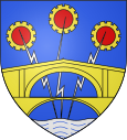
The city takes its name from the bridges that span the river here: a high stone arch bridge from 1611, the Pont Lesdiguières , replaced earlier collapsed bridges and has been a listed monument since 1898 . It was supplemented in 1873 by a second lower-lying bridge directly next to it, in order to meet the increased requirements of the increasing traffic. In the same year, the previous district of Claix on the other side of the river was given municipal independence. Both bridges can be seen in the coat of arms of the municipality.
| Population development | |||||||
|---|---|---|---|---|---|---|---|
| year | 1962 | 1968 | 1975 | 1982 | 1990 | 1999 | 2008 |
| Residents | 4,914 | 9,790 | 12,746 | 11,787 | 11,871 | 11,612 | 11,475 |
Transport and economy
Le Pont-de-Claix has a motorway junction (no. 7) on the short Autoroute A480 , which bypasses Grenoble and connects the Autoroute A48 in the north with the Autoroute A51 in the south.
The train station in Le Pont-de-Claix is served by trains of the regional railway company TER Rhône-Alpes on the Grenoble – Gap line.
Line A of the Grenoble tram is to be extended to Le Pont-de-Claix in 2018.
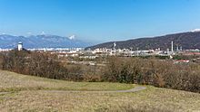
In the southeast of the city, east of the railway line, there is an area of around 120 hectares on which the Plate-forme chimique du Pont-de-Claix is located, an industrial complex of the chemical industry. Its history began in 1916 with the production of chlorine chemistry products . Today (2016) around 750 people are employed here in seven companies in the chemical industry (including Solvay and Air Liquide ).
tourism
The surroundings of the city offer opportunities for skiing, climbing and mountain hiking.
Town twinning
- Winsen (Luhe) , Lower Saxony, Germany
Web links
proof
- ↑ Monuments historiques: Vieux pont sur le Drac
- ↑ Brochure Bienvenue sur la Plate-forme du Pont-de-Claix ( page no longer available , search in web archives ) Info: The link was automatically marked as defective. Please check the link according to the instructions and then remove this notice. , French , accessed November 25, 2016


