Autoroute A 48
| Autoroute A48 in France | |||||||||||||||||||||||||||||||||||||||||||

|
|||||||||||||||||||||||||||||||||||||||||||
| |
|||||||||||||||||||||||||||||||||||||||||||
| map | |||||||||||||||||||||||||||||||||||||||||||
| Basic data | |||||||||||||||||||||||||||||||||||||||||||
| Operator: | AREA | ||||||||||||||||||||||||||||||||||||||||||
| further operator: | DIR Center-Est | ||||||||||||||||||||||||||||||||||||||||||
| Overall length: | 51 km | ||||||||||||||||||||||||||||||||||||||||||
|
Regions : |
|||||||||||||||||||||||||||||||||||||||||||
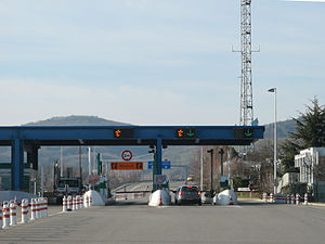
| Rives toll booth | |||||||||||||||||||||||||||||||||||||||||||
|
Course of the road
|
|||||||||||||||||||||||||||||||||||||||||||
The Autoroute A 48 , also known as Autoroute du Dauphiné , is a French motorway that begins in Bourgoin-Jallieu and ends in Grenoble . In 2011 a section was downgraded, as part of the route is intended for the operation of a new tram. The total length of the motorway is 51 km.
history
- August 12, 1967: Opening Grenoble - Voreppe (RD1075 - Departure 13)
- October 25, 1975: Opening of Voreppe - Sérézin-de-la-Tour (exit 13 - A 43)
- ?. ? 1993: Opening of the Voiron-Champfeuillet run (run 10)
- December 19, 1998: Opening of the Moirans-Mauvernay exit (exit 11)
Big cities on the highway
Web links
- Autoroute A 48 in German and French version of the SARATLAS
- Autoroute A 48 on WikiSara (French)


