
Moirans
| Moirans | ||
|---|---|---|

|
|
|
| region | Auvergne-Rhône-Alpes | |
| Department | Isère | |
| Arrondissement | Grenoble | |
| Canton | Tullins | |
| Community association | Pays Voironnais | |
| Coordinates | 45 ° 20 ' N , 5 ° 34' E | |
| height | 180–341 m | |
| surface | 20.06 km 2 | |
| Residents | 7,852 (January 1, 2017) | |
| Population density | 391 inhabitants / km 2 | |
| Post Code | 38430 | |
| INSEE code | 38239 | |
| Website | www.ville-moirans.fr | |
_fontaine.JPG) Square with fountain in Moirans |
||

Moirans is a French municipality with 7852 inhabitants (as of January 1 2017) in the department of Isère in the region Auvergne Rhône-Alpes . The municipality is located in the Arrondissement of Grenoble and belongs to the canton of Tullins .
geography
The Isère river limits the municipality to the south. Moirans is surrounded by the neighboring municipalities of Saint-Cassien in the north, Voiron in the northeast, Saint-Jean-de-Moirans in the east, Voreppe in the southeast, Saint-Quentin-sur-Isère in the south, Vourey in the west and Charnècles in the northwest.
The A49 autoroute and the former Route nationale 85 ( Route Napoleon , today Départementstrasse 1085) run through the municipality .
history
The place was mentioned as Morginum or Moringum (928) in the High Middle Ages (10th century).
Population development
| 1962 | 1968 | 1975 | 1982 | 1990 | 1999 | 2006 | 2017 | |
|---|---|---|---|---|---|---|---|---|
| 3959 | 4536 | 5106 | 6313 | 7133 | 7495 | 7860 | 7852 | |
| Sources: Cassini and INSEE | ||||||||
Attractions
- Saint-Pierre church from the 11th century
- Roman tower from the time of the barbarian invasions
- Château de la Motte from the 18th century
- Remains of the old Cordeliers convent from the 13th century
- Park de la Grille
- Town hall from the 18th century

Saint-Pierre church

roman tower
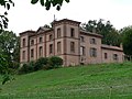
Château de la Motte

Park de la Grille
_St-Pierre.JPG)
_tour.jpg)


Personalities
- Cyrano de Dominicis (1927-2017), physicist