
La Sône
| La Sône | ||
|---|---|---|
|
||
| region | Auvergne-Rhône-Alpes | |
| Department | Isère | |
| Arrondissement | Grenoble | |
| Canton | Le Sud Grésivaudan | |
| Community association | Saint-Marcellin Vercors Isère Communauté | |
| Coordinates | 45 ° 7 ' N , 5 ° 17' E | |
| height | 160-270 m | |
| surface | 2.95 km 2 | |
| Residents | 584 (January 1, 2017) | |
| Population density | 198 inhabitants / km 2 | |
| Post Code | 38840 | |
| INSEE code | 38495 | |
| Website | http://www.la-sone.fr/ | |

La Sône is a French municipality with 584 inhabitants (as of January 1 2017) in the department of Isère in the region Auvergne Rhône-Alpes (before 2016 Rhône-Alpes ). It belongs to the Arrondissement of Grenoble and the canton of Le Sud Grésivaudan (until 2015: Saint-Marcellin ). The inhabitants are called Sonois .
geography
La Sône is about 36 kilometers west-southwest of Grenoble in the historic Dauphiné an der Isère landscape , which borders the municipality in the southeast, and the Merdaret river . La Sône is surrounded by the neighboring communities of Chatte in the north, west and east, Saint-Romans in the south and south-east, Saint-Just-de-Claix in the south and Saint-Hilaire-du-Rosier in the west and south-west.
Population development
| year | 1962 | 1968 | 1975 | 1982 | 1990 | 1999 | 2006 | 2013 |
| Residents | 688 | 641 | 671 | 665 | 574 | 590 | 620 | 591 |
| Source: Cassini and INSEE | ||||||||
Attractions
- Romanesque Saint-Pierre church from the 11th century
- La Sône Castle, former castle complex from the 12th century, rebuilt in the 15th century, monument historique since 1983
- medieval tower
- 19th century Saint-Chaumond manufacture
- Garden of the stone fountains, Monument historique

Saint-Pierre church

La Sône Castle
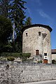
tower


