Saint-Maurice-en-Trièves
| Saint-Maurice-en-Trièves | ||
|---|---|---|
|
|
||
| region | Auvergne-Rhône-Alpes | |
| Department | Isère | |
| Arrondissement | Grenoble | |
| Canton | Matheysine-Trièves | |
| Community association | Trièves | |
| Coordinates | 44 ° 46 ′ N , 5 ° 40 ′ E | |
| height | 671-1,975 m | |
| surface | 12.9 km 2 | |
| Residents | 155 (January 1, 2017) | |
| Population density | 12 inhabitants / km 2 | |
| Post Code | 38930 | |
| INSEE code | 38424 | |
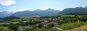
 View of Saint-Maurice-en-Trièves |
||
Saint-Maurice-en-Trièves is a French municipality with 155 inhabitants (as of January 1 2017) in the department of Isère in the region Auvergne Rhône-Alpes (before 2016: Rhône-Alpes ). The municipality is located in the arrondissement of Grenoble and belongs to the canton of Matheysine-Trièves (until 2015: canton of Clelles ). The inhabitants are called Lou San Maurizous .
geography
Saint-Maurice-en-Trièves is about 48 kilometers south of Grenoble . Saint-Maurice-en-Trièves is surrounded by the neighboring communities of Le Monestier-du-Percy in the north, Prébois in the east and northeast, Lalley in the south and east, Glandage in the southwest and Treschenu-Creyers in the west.
The former route nationale 75 (today's D1075) runs through the municipality .
Population development
| 1962 | 1968 | 1975 | 1982 | 1990 | 1999 | 2006 | 2013 | |
|---|---|---|---|---|---|---|---|---|
| 143 | 138 | 132 | 132 | 122 | 162 | 185 | 161 | |
| Sources: Cassini and INSEE | ||||||||
